Grassland Information
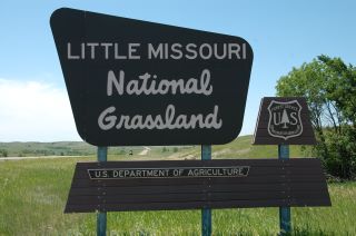
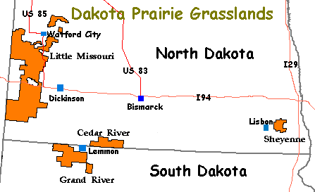
The Little Missouri National Grassland, one of four in the Dakota
Prairie Grasslands, is found in western North Dakota and is comprised
of 503,000 acres - see map below. The grassland is administered by
the Dakota Prairie Grasslands office. There are eight developed
campgrounds all of which meet the selection criteria.
The Little Missouri National Grassland (NG) is a place where
people experience the rugged, unspoiled beauty of the Dakota
Badlands. The land invites explorations. The sights and sounds
stimulate the senses. It is a great place for inspiration and
imagination. Recreation opportunities are more developed on the
Little Missouri NG than in the other Dakota Prairie Grasslands
making experiencing the Little Missouri NG easier. Activities
such as camping, hiking, and horse back riding are a great way to
discover the delights of this little grassland on the western
edge of North Dakota.
Stretching the length of the Little Missouri NG is the Maah Daah
Hey Trail from which many of the Grassland's recreation
opportunities radiate. Going from the top to almost the bottom
of the grassland, this 97-mile trail is a mountain biker and
equestrian's delight. Hikers are, of course, welcomed. (FYI:
Plans were in the works during our visit to expand the Maah Daah
Hey an additional 40 miles south.)
The phrase "Maah Daah Hey" comes from the Native American
language of the Mandan Hidatsa people and means "grandfather,
long-lasting." The symbol for the trail is a turtle, which is
branded on the trail's markers for the full length of the route.
The turtle symbol was adopted from the Lakota Sioux people who
see the turtle as patient, determined, steadfast, long-lived, and
having fortitude. The name given and the symbol used for this
trail is a nice nod to two cultures that used this area as their
home for hundreds of years.
Although they aren't on the Maah Daah Hey trail, there are a
number of developed campgrounds near the trails. On the southern
banks of the Little Missouri River is CCC campground (named for
the Civilian Conservation Corp camp once located across the river
from campground's location), where the Maah Daah Hey trail
begins. The CCC campground is also a good base camp for visiting
the Theodore Roosevelt National Park's North Unit and explore the
sights and attractions of Watford City and surrounding area.
Next, heading south are Bennett campground, Magpie Camp, Elkhorn
Camp and Wannagan Camp. All welcome horses and their riders and
are a short, maybe half mile or so, distance from the Maah Daah
Hey trail. With drinking water, formal campsites, and often
pleasant shade, these campgrounds offer a welcomed break from
camping along the trail. Elkhorn Camp is also the closest
campground to Theodore Roosevelt National Park's Elkhorn Ranch
Site. The ruins found here are one of the two ranches
established by Theodore Roosevelt about a hundred years ago.
The longest side trip off the Maah Daah Hey trail is the Buffalo
Gap campground. This side trail bypasses the Theodore Roosevelt
National Park's South Unit while the Maah Daah Hey passes through
the Park. However, campers at nearby Buffalo Gap campground are
not trail riders but people who are passing through on I-94.
Located about halfway between Beach and Medora, ND, this
campground, the most developed in the Little Missouri NG, is a
great location for an overnight stay or as a base camp to explore
the sights of the Theodore Roosevelt National Park and the
attractions of Medora.
It might be hard to see the Little Missouri NG as anything other
than what it is today. However, the area now designated as
"grassland" was settled in the 1800s under a variety of
"Homestead Acts" which opened the land to people, generally
farmers, and helped to settle the west. A prolonged period of
drought in the late 1920s into the 1930s caused some homesteads
on sub-marginal farmland (a location receiving 15 or less inches
of annual moisture) to literally dry up and blow away. During
this time, Congress established the Land Utilization Program
(LUP) which bought homesteads from bankrupt private owners and
returned it to public land status. The Civilian Conservation
Corps (CCC) helped to stabilize the eroding soil by re-seeding it
and applying other conservation techniques. In the 1950s, the LUP
holdings were assigned to the USDA Forest Service which was
tasked with management of these sub-marginal lands. Over the
years the Forest Service has established some twenty National
Grasslands. "The designation of the area as National Grassland is
not a description of the area as much as a statement of policy
and effort to restore the area to a multiple of uses and benefits."
The Little Missouri NG has come a long way from the dry and
ravaged land it was in the 1930s. Perhaps Sather Lake Recreation
Area best illustrates the land's recovery from those bygone days.
Along the western edge of the Little Missouri NG, slender Sather
Lake winds through the gentle rolling hills, its precious water
waiting until the local ranchers need it for their fields,
provides a peaceful location for campers and a variety of birds,
is surrounded by lush, green fields as far as the eye can see.
Take a chance, come and visit the Little Missouri NG. It may not
be well known but holds many wonders to discover.
ADDRESSES
SUPERVISOR ADDRESS
2000 Miriam Circle
Bismarck, North Dakota 58501
701-989-7300

RANGER DISTRICT ADDRESSES
McKenzie
1905 S. Main Street
Watford City, North Dakota 58854
701-842-8500

Medora
99 23rd Ave W, Suite B
Dickinson, North Dakota 58601
701-227-7800
|