Campground List
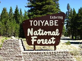
CAMPGROUND NAME: Bob Scott

VISIT DATE: 09/10/2002

UPDATE DATE: 7/12/2025

STATE: Nevada

REGION: Intermountain

RANGER DISTRICT: Austin

NEAREST CITY/TOWN: Austin

RESERVATIONS: No

DIRECTIONS:
From Austin, NV, take US Rt. 50 east 6.1 miles to campground
sign.  Turn left at sign into campground.

GENERAL COMMENTS:
The elevation is 7,300 ft.

Bob Scott campground is a well-loved National Forest site located just outside
Austin, Nevada, along the iconic US Highway 50 - famously dubbed "The Loneliest
Road in America". This transcontinental highway stretches from West Sacramento,
California to Ocean City, Maryland, and in Nevada it passes through vast, remote
landscapes.

Nestled in the Toiyabe Mountains at a high elevation, the campground is a single
loop with a view of Bob Scott Summit. Mature Pinyon pine and Sagebrush are the
primary vegetation. The entire campground is in the open and has fair privacy
between campsites. It offers a peaceful and scenic setting ideal for hiking,
mountain biking, fishing and stargazing. Visitors can choose from individual sites
or the group site if it has not been previously reserved. Each site is equipped
with picnic tables and fire rings - making it a convenient overnight stop for road
trippers and outdoor enthusiasts alike.

What's in a Name?
US Highway 50 earned its nickname due to the long, desolate stretches it crosses -
where signs of civilization are far and few between. The route winds through expansive
desert valleys divided by dramatic mountain ranges.

SEASONS
Open Seasonal: Yes
Open All Year: No

Seasonal Comment:
Open mid-May through late October.

NOTE: 6/29/2025 - Bob Scott Campground is currently closed for
renovations. Estimated completion of renovations is August 31, 2025.
Contact ranger district office for status.

RATE AND MAXIMUM STAY PERMITTED
Rate: $10 per day
Maximum Stay Permitted (days): 14

CAMPGROUND SITE CONFIGURATION
No. RV Sites: 0
No. Tent Sites: 0
No. Combined Sites (Tent or RV): 10

   Total Sites: 10

Tent Pads: No
Open Sites: Yes
Wooded Sites: No

No. Tables on Sites: 10
No. Grilles on Sites: 10
Equestrian Camping:  No

RV INFORMATION
Hookups: None
No. RV Pull Throughs: 4
Waste Station: No
Average Parking Apron Size: 13' X 36'

Comments:
The parking aprons are paved.

FACILITIES
Vaults: Yes
Flush Toilets: Yes
Hot Showers: No
Wheelchair Friendly Toilets: No

Public Phone: No
Playground: No
No. Water Spigots (non-site): 5
  No. Threaded: 5

WATER SPORTS - None

HIKING - No

FISHING - No

CAMPGROUND NAME: Bootleg

VISIT DATE: 09/05/2002

UPDATE DATE: 7/12/2025

STATE: California

REGION: Intermountain

RANGER DISTRICT: Bridgeport

NEAREST CITY/TOWN: Walker

RESERVATIONS: No

DIRECTIONS:
From Walker, CA, take US Rt. 395 south 7.7 miles to campground on
right.

GENERAL COMMENTS:
The elevation is 6,600 ft.

This campground, excellent for overnighters or long-term campers,
is located on the west side of a valley carved by Walker River.
The river is still actively widening the valley causing small
landslides on the east wall that can be heard from campground.
The sound of Walker River can also be heard from some camp sites.
The campground is comprised of a spur leading to two loops in a
stand of Jeffrey pine.  Wild rose and Sagebrush make up the
understory and widely spaced sites mean excellent privacy.  The
campground is rocky making pitching a tent challenging, but is
compensated at some sites with tent pads.  Without a "bad" camp
site, this is a pretty campground that awaits discovery.  Group
tent sites are limited.  Firewood is available for fee.

It is illegal and unlawful to feed wildlife of any kind.  To
report sightings of wildlife feeding, contact the Bridgeport
Ranger Station at 760-932-7070.

SEASONS
Open Seasonal: Yes
Open All Year: No

Seasonal Comment:
Open late May through mid-September - weather dependent

RATE AND MAXIMUM STAY PERMITTED
Rate: $20 per day
Maximum Stay Permitted (days): 30

CAMPGROUND SITE CONFIGURATION
No. RV Sites: 0
No. Tent Sites: 0
No. Combined Sites (Tent or RV): 63

   Total Sites: 63

Tent Pads: Yes
Open Sites: Yes
Wooded Sites: Yes

No. Tables on Sites: 63
No. Grilles on Sites: 63
Equestrian Camping:  No

RV INFORMATION
Hookups: None
No. RV Pull Throughs: 5
Waste Station: No
Average Parking Apron Size: 13' X 50'

Comments:
The parking aprons are paved.  The campground accommodates any
size RV.

FACILITIES
Vaults: No
Flush Toilets: Yes
Hot Showers: No
Wheelchair Friendly Toilets: No

Public Phone: No
Playground: No
No. Water Spigots (non-site): 0

WATER SPORTS - None

HIKING - No

FISHING
Rainbow and Brown trout

CAMPGROUND NAME: Buckeye

VISIT DATE: 09/06/2002

UPDATE DATE: 7/12/2025

STATE: California

REGION: Intermountain

RANGER DISTRICT: Bridgeport

NEAREST CITY/TOWN: Bridgeport

RESERVATIONS: No

DIRECTIONS:
In Bridgeport, CA, at intersection of US Rt. 395 and Twin Lakes
Rd., take Twin Lakes Rd. south 7.2 miles to campground sign.
Turn right at sign onto Buckeye Rd. and go 2.8 miles to a "Y"
intersection and campground sign.  Bear left and go 0.7 miles to
campground.

NOTE: After 0.4 miles, Buckeye Rd. becomes dirt with washboard
surface.

GENERAL COMMENTS:
The elevation is 7,520 ft.

The campground, located on the east ridge of Buckeye Mountain
well above Buckeye Creek, stretches out for 0.3 miles and is
composed of five loops - Loop 1, sites 1-11; Loop 2 is a trailhead;
Loop 3, sites 13-21; Loop 4, sites 23-41; and Loop 5, sites 42-68.
Loop 1 is at far end of campground with the smallest parking
aprons.  Loop 5 is closest to campground entrance.  Loop 4 has
the largest parking aprons.  Overall, the overstory is comprised
of Jeffrey pine with some fir and Aspen; the Aspen are mostly in
loop 5.  The understory is mostly sagebrush with a ground
cover of dirt and pine needles.  Some camp sites in Loop 4
have a spectacular view of valley and distant mountains.  Loop 3
is tent only.  Unless using the paved parking apron, pitching a
tent on some sites in this loop will be a challenge.  Loop 3 is
not conducive to group camping either.  All the trees are second
growth as they were harvested in 1862/63 and used in the
construction of houses and mines in Bodie, CA.  Firewood is
available for a fee.

Buckeye Hot Springs is approximately 1 mile from the campground.

This is bear country; practice safe food storage techniques.
It is illegal and unlawful to feed wildlife of any kind.  To
report sightings of wildlife feeding, contact the Bridgeport
Ranger Station at 760-932-7070.

NOTE: Loop numbers are arbitrarily established by the authors.

SEASONS
Open Seasonal: Yes
Open All Year: No

Seasonal Comment:
Open late May through late September - weather dependent

RATE AND MAXIMUM STAY PERMITTED
Rate: $20 per day
Maximum Stay Permitted (days): 14

CAMPGROUND SITE CONFIGURATION
No. RV Sites: 0
No. Tent Sites: 10
No. Combined Sites (Tent or RV): 55

   Total Sites: 65

Tent Pads: No
Open Sites: Yes
Wooded Sites: Yes

No. Tables on Sites: 65
No. Grilles on Sites: 65
Equestrian Camping:  No

RV INFORMATION
Hookups: None
No. RV Pull Throughs: 9
Waste Station: No
Average Parking Apron Size: 12' X 43'

Comments:
The parking aprons are paved.

RV dump stations, with potable water, are available for a fee at:
Annett's Mono Village (38.148, - 119.378) 13425 Twin Lakes Rd, Bridgeport, CA;
Paradise shoes RV Park (38.288, -119.215) 2344 CA - 182, Bridgeport, CA; and,
Mono Vista RV Park (37.959, -119.113) 57 Beaver Lane, Lee Vining, CA

FACILITIES
Vaults: Yes
Flush Toilets: No
Hot Showers: No
Wheelchair Friendly Toilets: Yes

Public Phone: No
Playground: No
No. Water Spigots (non-site): 0

WATER SPORTS - None

HIKING
Buckeye Creek Trail (foot) - 8.8 miles

FISHING
Rainbow trout

CAMPGROUND NAME: Chris Flat

VISIT DATE: 09/05/2002

UPDATE DATE: 7/12/2025

STATE: California

REGION: Intermountain

RANGER DISTRICT: Bridgeport

NEAREST CITY/TOWN: Walker

RESERVATIONS: No

DIRECTIONS:
From Walker, CA take US Rt. 395 south 9.2 miles to campground on
left.

GENERAL COMMENTS:
The elevation is 6,740 ft.

The campground's two unnamed loops, mostly in the open, stretch
along the west bank of Walker River.  Most camp sites have a good
view of the sage brush-covered hillsides east of campground.
River willow shrubs line the river's bank while pines provide
limited shade for campground.  Camp sites are nicely separated
providing good privacy.  Traffic noise can be heard throughout
campground.  Firewood is available for a fee.

The beautiful Eastern Sierra Scenic Byway (U.S 395)  passes by the
campground.

This is bear country; practice safe food storage techniques.
It is illegal and unlawful to feed wildlife of any kind.  To
report sightings of wildlife feeding, contact the Bridgeport
Ranger Station at 760-932-7070.

SEASONS
Open Seasonal: Yes
Open All Year: No

Seasonal Comment:
Open late April through early October - weather dependent

RATE AND MAXIMUM STAY PERMITTED
Rate: $28 per day
Maximum Stay Permitted (days): 14

CAMPGROUND SITE CONFIGURATION
No. RV Sites: 0
No. Tent Sites: 0
No. Combined Sites (Tent or RV): 14

   Total Sites: 14

Tent Pads: No
Open Sites: Yes
Wooded Sites: Yes

No. Tables on Sites: 14
No. Grilles on Sites: 14
Equestrian Camping:  No

RV INFORMATION
Hookups: None
No. RV Pull Throughs: 0
Waste Station: No
Average Parking Apron Size: 13' X 43'

Comments:
The parking aprons are paved.

FACILITIES
Vaults: Yes
Flush Toilets: No
Hot Showers: No
Wheelchair Friendly Toilets: Yes

Public Phone: No
Playground: No
No. Water Spigots (non-site): 3
  No. Threaded: 1

Comments:
The only water spigot is at campground's entrance.

WATER SPORTS - None

HIKING - No

FISHING
Rainbow and Brown trout

CAMPGROUND NAME: Crags

VISIT DATE: 09/06/2002

UPDATE DATE: 7/15/2025

STATE: California

REGION: Intermountain

RANGER DISTRICT: Bridgeport

NEAREST CITY/TOWN: Bridgeport

RESERVATIONS: 1-877-444-6777 or make on-line reservation

DIRECTIONS:
In Bridgeport, CA, at intersection of US Rt. 395 and Twin Lakes
Rd., take Twin Lakes Rd. south 9.9 miles to "campgrounds" sign
(South Twin Rd.).  Turn left onto South Twin Rd. and go 0.2 miles
to Crags Campground sign.  Turn left and go 0.1 miles to
Matterhorn Camp Loop on the left and Sawtooth Camp Loop on the
right.

GENERAL COMMENTS:
The elevation is 7,000 ft.

This campground is one of five in the Twin Lakes Recreation Area.
While the campground is not on a lake, it is within 0.2 miles of
the Lower Twin Lake's no-charge boat ramp next to Lower Twin
campground.  It is comprised of two loops - Matterhorn Camp Loop
and Sawtooth Camp Loop.  Sawtooth has flush toilets and a vault,
both wheelchair friendly and each has an outstanding view of
Sawtooth Ridge.  The Matterhorn has only a vault toilet and
partial view of Sawtooth Ridge.  Each camp site in this loop has
a camp stove pedestal and cement pad for table and grille area.
The tent site's view (Matterhorn Camp Loop) of the Bridger Valley
is outstanding.  Although all camp sites are in the open, spacing
between them is ample enough to provide good privacy.  The
understory is Sagebrush.

Limited groceries and boat rentals are available at both Mono
Village and Twin Lakes Resorts.  Mono Village also has a
restaurant and gas while Twin Lakes Resorts has coin operated
laundry.  Saturday night campfires (interpretive
programs) are provided at Robinson Creek campground - look at fee
board for information.  Firewood is available for a fee.

This is bear country; practice safe food storage techniques.
It is illegal and unlawful to feed wildlife of any kind.  To
report sightings of wildlife feeding, contact the Bridgeport
Ranger Station at 760-932-7070.

SEASONS
Open Seasonal: Yes
Open All Year: No

Seasonal Comment:
Sawtooth loop: Open May 16 through October 19 - weather dependent
Matterhorn loop: Open April 17 through October 6 - weather dependent

RATE AND MAXIMUM STAY PERMITTED
Rate: $30 per day - single
$50 per day - double
Maximum Stay Permitted (days): 14

CAMPGROUND SITE CONFIGURATION
No. RV Sites: 0
No. Tent Sites: 1
No. Combined Sites (Tent or RV): 51

   Total Sites: 52

Tent Pads: No
Open Sites: Yes
Wooded Sites: No

No. Tables on Sites: 52
No. Grilles on Sites: 52
Equestrian Camping:  No

RV INFORMATION
Hookups: None
No. RV Pull Throughs: 4
Waste Station: No
Average Parking Apron Size: 12' X 52'

Comments:
The parking aprons are paved.

RV dump stations, with potable water, are available for a fee at:
Annett's Mono Village (38.148, - 119.378) 13425 Twin Lakes Rd, Bridgeport, CA;
Paradise shoes RV Park (38.288, -119.215) 2344 CA - 182, Bridgeport, CA; and,
Mono Vista RV Park (37.959, -119.113) 57 Beaver Lane, Lee Vining, CA

FACILITIES
Vaults: Yes
Flush Toilets: Yes
Hot Showers: No
Wheelchair Friendly Toilets: Yes

Public Phone: No
Playground: No
No. Water Spigots (non-site): 11
  No. Threaded: 10

Comments:
Coin operated showers are available at Twin Lakes Resort, south
of campground.

WATER SPORTS
Lake: Yes
Swimming (provided): No
Sailing: No
Boat Ramp: Yes
Boat Carry Down Access: No
Power Boating: Yes
Boating (no power): Yes
Water Skiing: No
Rafting (whitewater): No
Kayaking (whitewater): No

Comments:
There are two lakes - Lower Twin Lake and Upper Twin Lake.  Each is
about 320 acres.  Lower Twin Lake has a 5mph restriction and a free
boat ramp.  Another boat ramp for Lower Twin Lake is available, for a
fee, across from Twin Lakes General Store.  A third boat launch is for
Upper Twin Lake and is available, for a fee, at Mono Village Resort, south
end of lake.  Except for water skiing being permitted only from 10AM through
3PM, there are no restrictions on Upper Twin Lake.

HIKING
Although there are no trail heads at campground, the following
trails are in the Recreation Area:

Tamarack Lake (foot) - 4 miles
Horse Creek (foot) - 2 miles
Robinson Creek #22077 (foot) - 9 miles
   Provides access to Hoover Wilderness

FISHING
Robinson Creek - Rainbow trout
Both Upper and Lower Twin Lakes - Kokanee salmon and
Brown and Rainbow trout

CAMPGROUND NAME: Crystal Springs

VISIT DATE: 09/03/2002

UPDATE DATE: 7/15/2025

STATE: Nevada

REGION: Intermountain

RANGER DISTRICT: Carson

NEAREST CITY/TOWN: Minden

RESERVATIONS: No

DIRECTIONS:
In Minden, NV, at intersection of US Rt. 395 and State Route 88,
take Rt. 88 west 15.5 miles to campground sign.  Turn left at
sign onto Crystal Springs Rd. and go 0.1 miles to campground on
right.

GENERAL COMMENTS:
The elevation is 6,240 ft.

The campground, physically located in California close to West Fork
Carson River, is comprised of two overlapping, unnamed loops and a
spur.  The loops terrace up the west side of West Carson Canyon
giving each camp site a view of the canyon's barren and rugged
eastern wall.  Jeffrey pines and fir dot the hillside and provide
some shade.  The campground is the most RV-friendly along the
State Rt. 88/West Carson Canyon corridor.

This is bear country; practice safe food storage techniques.

SEASONS
Open Seasonal: Yes
Open All Year: No

Seasonal Comment:
Open late April through September - weather depentent

RATE AND MAXIMUM STAY PERMITTED
Rate: $24 per day
Maximum Stay Permitted (days): 14

CAMPGROUND SITE CONFIGURATION
No. RV Sites: 0
No. Tent Sites: 2
No. Combined Sites (Tent or RV): 16

   Total Sites: 18

Tent Pads: No
Open Sites: Yes
Wooded Sites: Yes

No. Tables on Sites: 18
No. Grilles on Sites: 18
Equestrian Camping:  No

RV INFORMATION
Hookups: Yes, see comments below
No. RV Pull Throughs: 1
Waste Station: No
Average Parking Apron Size: 10' X 32'

Comments:
The parking aprons are paved.

FACILITIES
Vaults: Yes
Flush Toilets: No
Hot Showers: No
Wheelchair Friendly Toilets: Yes

Public Phone: No
Playground: No
No. Water Spigots (non-site): 6
  No. Threaded: 6

WATER SPORTS - None

HIKING - No

FISHING - Trout

CAMPGROUND NAME: Fletcher View

VISIT DATE: 09/15/2002

UPDATE DATE: 7/15/2025

STATE: Nevada

REGION: Intermountain

RANGER DISTRICT: Spring Mountains National Recreation Area

NEAREST CITY/TOWN: Las Vegas

RESERVATIONS: 1-877-444-6777 or make on-line reservation

DIRECTIONS:
In Las Vegas, NV, at intersection of Centennial Pkwy (Exit 91)
and US Rt. 95, take Rt. 95 north 4.1 miles to Kyle Canyon/State
Rt. 157 signs.  Turn left onto Rt. 157 and go 18.4 miles to
campground sign.  Turn left into campground.

GENERAL COMMENTS:
The elevation is 7,000 ft.

The campground, one of four in the Spring Mountains National
Recreation Area, stretches up Kyle Canyon along a wash beside State
Rt. 157.  Most sites have tent pads and either a pedestal grille or
camp stove stand along with usual table and fire ring.  A pleasant
mixture of Ponderosa pine, Mountain mahogeny, and Gambel oak provide
ample shade.  Privacy between camp sites is good.  Fox and deer
sightings are possible.  Firewood available for a fee.  Flash
flooding is a possible concern mid-July through mid-August.
Interpretative programs are offered at the Spring Mountains NRAs
Visitor Center; go to www.gomtcharleston.com for information and
schelude.

Drive up to the Mt. Charleston Lodge for lunch or dinner.  Sit out
on the balcony with your puppy.  They even have a doggie menu.  Enjoy
the views.

Another day trip is Red Rock Canyon National Conservation Area.  There
are "Solar Slab," "Johnny Vegas," "Olive Oil" and many other trails to
challenge rock climbers.  Mountain bikers have "Mustang" trail and hikers
have a whole host of choices.

SEASONS
Open Seasonal: No
Open All Year: Yes

RATE AND MAXIMUM STAY PERMITTED
Rate: $33 per day - single
$58 per day - double
Note: Reservations not accespted mid-July through
mid-September (monsoon season)
Maximum Stay Permitted (days): 14

CAMPGROUND SITE CONFIGURATION
No. RV Sites: 0
No. Tent Sites: 0
No. Combined Sites (Tent or RV): 10

   Total Sites: 10

Tent Pads: Yes
Open Sites: Yes
Wooded Sites: Yes

No. Tables on Sites: 10
No. Grilles on Sites: 10
Equestrian Camping:  No

RV INFORMATION
No. Full Hookups (includes waste): 0
No. Water and Electric Only: 0
No. Water Only: 0
No. Electric Only: 10

No. RV Pull Throughs: 0
Waste Station: No
Average Parking Apron Size: 15.5' X 42'

Comments:
The parking aprons are paved.  An RV waste station is available
at the Flying J gas station in Las Vegas at intersection of I-15
and Cheyenne Ave (Exit 41 west) - no fee.

FACILITIES
Vaults: No
Flush Toilets: Yes
Hot Showers: Yes
Wheelchair Friendly Toilets: Yes

Public Phone: No
Playground: No
No. Water Spigots (non-site): 4
  No. Threaded: 4

Comments:
Potable water may not be available in winter.

WATER SPORTS - None

HIKING - No

Comments:
Although there is no trail head at campground, the following are
a few of the 12 trails in the Spring Mountains National
Recreation Area:

Bristlcone Trail (foot and mountain bike) - 6.1 miles
Desert View (foot) - 0.1 miles
Cathedral Rock Trail (foot) - 1.4 miles
Trail Canyon (foot) - 2 miles

FISHING - No

CAMPGROUND NAME: Green Creek

VISIT DATE: 09/07/2002

UPDATE DATE: 8/18/2025

STATE: California

REGION: Intermountain

RANGER DISTRICT: Bridgeport

NEAREST CITY/TOWN: Bridgeport

RESERVATIONS: No

DIRECTIONS:
From Bridgeport, CA, take US Rt. 395 south 3.8 miles to Green
Creek Rd. sign.  Turn right after sign onto Green Creek Rd.
(Forest Rt. 142) and go 3.5 miles to an intersection and Green
Creek sign.  Turn right, continuing on Rt. 142, and go 5.4 miles
to campground.

NOTE: Green Creek Rd./Forest Rt. 142 is dirt.  After 5 miles it
narrows down to a rocky single-lane road.

GENERAL COMMENTS:
The elevation is 7,500 ft.

The campground is tucked in among Aspen and Lodgepole pine beside
Green Creek.  Several camp sites are next to creek while others
are along an ancient wall of boulders.  It provides a good base
camp for exploring the nearby lakes and falls.  The ground cover
is comprised of tall grass throughout much of campground.
Privacy between camp sites is fair to good.  Firewood is
available for a fee.

It is illegal and unlawful to feed wildlife of any kind.  To
report sightings of wildlife feeding, contact the Bridgeport
Ranger Station at 760-932-7070.

SEASONS
Open Seasonal: Yes
Open All Year: No

Seasonal Comment:
Open late April through early October - weather dependent

RATE AND MAXIMUM STAY PERMITTED
Rate: $22 per day
Maximum Stay Permitted (days): 14

CAMPGROUND SITE CONFIGURATION
No. RV Sites: 0
No. Tent Sites: 2
No. Combined Sites (Tent or RV): 8

   Total Sites: 10

Tent Pads: No
Open Sites: No
Wooded Sites: Yes

No. Tables on Sites: 10
No. Grilles on Sites: 10
Equestrian Camping:  No

RV INFORMATION
Hookups: None
No. RV Pull Throughs: 1
Waste Station: No
Average Parking Apron Size: 11' X 32'

Comments:
The parking aprons are dirt.

RV dump stations, with potable water, are available for a fee at:
Annett's Mono Village (38.148, - 119.378) 13425 Twin Lakes Rd, Bridgeport, CA;
Paradise shoes RV Park (38.288, -119.215) 2344 CA - 182, Bridgeport, CA; and,
Mono Vista RV Park (37.959, -119.113) 57 Beaver Lane, Lee Vining, CA


FACILITIES
Vaults: Yes
Flush Toilets: No
Hot Showers: No
Wheelchair Friendly Toilets: No

Public Phone: No
Playground: No
No. Water Spigots (non-site): 0

WATER SPORTS - None

HIKING
Green Creek Trail (foot & horse) - 6 miles
     Accesses Hoover Wilderness and Yosemite National
     Park.

FISHING
Green Creek is known for excellent fishing.
Rainbow trout.

CAMPGROUND NAME: Hilltop

VISIT DATE: 09/15/2002

UPDATE DATE: 7/15/2025

STATE: Nevada

REGION: Intermountain

RANGER DISTRICT: Spring Mountains National Recreation Area

NEAREST CITY/TOWN: Las Vegas

RESERVATIONS: 1-877-444-6777 or make on-line reservation

DIRECTIONS:
In Las Vegas, NV, at intersection of Centennial Pkwy (Exit 91) and
US Rt. 95, take Rt. 95 north 4.1 miles to Kyle Canyon/State Rt. 157
signs.  Turn left onto Rt. 157 and go 17.6 miles to Lee Canyon/State
Rt. 158 signs.  Turn right onto Rt. 158 and go 4.6 miles (up a steep
grade) to campground sign.  Turn right at "Youth Camp" sign and go
0.2 miles to campground.

NOTE: The Forest Service advises no travel trailers over 25 ft. in
campground.  The authors also advise motor homes okay up to 32 ft.

GENERAL COMMENTS:
The elevation is 8,400 ft.

The campground, one of four in the Spring Mountains National Recreation
Area (NRA), meanders around the top of a hill providing camp sites with
magnificent panoramic views of Spring Mountains, and in the distance,
Sheep Mountains, Mercury Test Site, and lights of Las Vegas. Hilltop
campground was originally part of the Deer Creek Campground built by the
Civilian Conservation Corps (CCC).  It is the oldest single family
campground in the NRA.  The nearby Juniper Mountain Bike network of trails
has increased Hilltop's popularity with that user group.  Mountain mahogony,
Ponderosa pine and juniper shade camp sites but do not limit the views.
Although there is little ground cover, except rocks, placement of sites does
provide good privacy. Gas and limited groceries are available in Indian
Springs, 13.2 miles north on US Rt. 95. Interpretative programs are offered
at the Spring Mountains NRA's Visitor Center; visit www.gomtcharleston.com
for information and schedule.

Drive up to the Mt. Charleston Lodge for lunch or dinner.  Sit out on the
balcony with your puppy.  They even have a doggie menu.  Enjoy the views.

SEASONS
Open Seasonal: Yes
Open All Year: No

Seasonal Comment:
Open May 15 through November 3

RATE AND MAXIMUM STAY PERMITTED
Rate: $19 per day - tent
$23 per day - single
$45 per - double
Maximum Stay Permitted (days): 14

CAMPGROUND SITE CONFIGURATION
No. RV Sites: 0
No. Tent Sites: 5
No. Combined Sites (Tent or RV): 30

   Total Sites: 35

Tent Pads: Yes
Open Sites: Yes
Wooded Sites: Yes

No. Tables on Sites: 35
No. Grilles on Sites: 35
Equestrian Camping: No

RV INFORMATION
Hookups: None
No. RV Pull Throughs: 3
Waste Station: No
Potable Water at Waste Station: No
Average Parking Apron Size: 11' X 40'

Comments:
The parking aprons are paved.  The Forest Service advises "No Trailers
over 25 ft."  The authors also advise motor homes okay up to 32 ft.  A
narrow interior road with a couple "hairpin" curves make this campground
the least big rig-friendly in the NRA.   An RV waste station is available
for no fee at the Flying J gas station in Las Vegas at intersection of
I-15 and Cheyenne Ave (Exit 41 west).

FACILITIES
Vaults: Yes
Flush Toilets: Yes
Hot Showers: Yes
Wheelchair Friendly Toilets: Yes

Public Phone: No
Playground: No
No. Water Spigots (non-site): 7
  No. Threaded: 4

Comments:
The showers are coin operated.

WATER SPORTS None

HIKING
Although there is no trail head at campground, the following are
a some of trails in the Spring Mountains National Recreation Area:

Robber's Roost (foot) - .7 miles
Bristlcone Trail (foot and mountain bike) - 6.1 miles
Desert View (foot) - 0.1 miles
Fletcher Canyon (foot) - 1.6 miles
Mary Jane Falls (foot) - 1.5 miles

FISHING No

CAMPGROUND NAME: Honeymoon Flat

VISIT DATE: 09/05/2002

UPDATE DATE: 7/15/2025

STATE: California

REGION: Intermountain

RANGER DISTRICT: Bridgeport

NEAREST CITY/TOWN: Bridgeport

RESERVATIONS: 1-877-444-6777 or make on-line reservation

DIRECTIONS:
In Bridgeport, CA, at intersection of US Rt. 395 and Twin Lakes
Rd., take Twin Lakes Rd. south 8 miles to campground sign.  Turn
right at sign for campground's first section or go 0.1 miles to
second section on left.

GENERAL COMMENTS:
The elevation is 7,000 ft.

This campground is one of five in the Twin Lakes Recreation Area.
While the campground is not on a lake, it is within 2 miles of
Lower Twin Lake's no-charge boat ramp - next to Twin Lakes
campground.  Separated by Twin Lakes Rd., the campground has two
sections.  The first section is on the west side of Twin Lakes
Rd. and offers camp sites with shade.  A number of sites in this
section are along Robinson Creek.  The second section has most of
the pull-throughs and more open, sunny sites.  Camp sites with
incredible views of Sawtooth Ridge are available in both
sections.  Although the campground is the most rustic in the
Recreation Area, it is popular with campers looking for quiet and
solitude.  Aspen, Jeffrey and Lodgepole pines provide shade,
while River willow shrubs and wide separation between camp sites
provide good privacy.

Limited groceries and boat rentals are available at both Mono
Village and Twin Lakes Resorts.  Mono Village also has a
restaurant and gas.  Saturday night campfires (interpretive
programs) are provided at Robinson Creek campground - look at fee
board for information.  Firewood is available for a fee.

This is bear country; practice safe food storage techniques.
It is illegal and unlawful to feed wildlife of any kind.  To
report sightings of wildlife feeding, contact the Bridgeport
Ranger Station at 760-932-7070.

SEASONS
Open Seasonal: Yes
Open All Year: No

Seasonal Comment:
Open May 15 through November 21 - weather dependent

RATE AND MAXIMUM STAY PERMITTED
Rate: $30 per day - single
$50 per day - double
Maximum Stay Permitted (days): 14

CAMPGROUND SITE CONFIGURATION
No. RV Sites: 0
No. Tent Sites: 2
No. Combined Sites (Tent or RV): 32

   Total Sites: 34

Tent Pads: No
Open Sites: Yes
Wooded Sites: Yes

No. Tables on Sites: 32
No. Grilles on Sites: 34
Equestrian Camping:  No

RV INFORMATION
Hookups: None
No. RV Pull Throughs: 10
Waste Station: No
Average Parking Apron Size: 14' X 45'

Comments:
The parking aprons are gravel and dirt.  The campground
accommodates most any size RV.

RV dump stations, with potable water, are available for a fee at:
Annett's Mono Village (38.148, - 119.378) 13425 Twin Lakes Rd, Bridgeport, CA;
Paradise shoes RV Park (38.288, -119.215) 2344 CA - 182, Bridgeport, CA; and,
Mono Vista RV Park (37.959, -119.113) 57 Beaver Lane, Lee Vining, CA

FACILITIES
Vaults: Yes
Flush Toilets: No
Hot Showers: No
Wheelchair Friendly Toilets: Yes

Public Phone: No
Playground: No
No. Water Spigots (non-site): 8
  No. Threaded: 8

Comments:
Coin operated showers are available at Twin Lakes Resort, south
of campground,

WATER SPORTS
Lake: Yes
Swimming (provided): Yes
Sailing: No
Boat Ramp: Yes
Boat Carry Down Access: No
Power Boating: Yes
Boating (no power): Yes
Water Skiing: No
Rafting (whitewater): No
Kayaking (whitewater): No

Comments:
There are two lakes - Lower Twin Lake and Upper Twin Lake.  Each is about
320 acres.  Lower Twin Lake has a 5mph restriction and a free boat ramp.
Another boat ramp for Lower Twin Lake is available, for a fee, across from
Twin Lakes General Store.  A third boat launch is for Upper Twin Lake and is
availabe, for a fee, at Mono Village Resort, south end of lake.  Except for water
skiing being permitted only from 10AM through 3PM, there are no restrictions on
Upper Twin Lake.

HIKING
Although there are no trail heads at campground, the following
trails are in the Recreation Area:

Tamarack Lake (foot) - 4 miles
Horse Creek (foot) - 2 miles
Robinson Creek #22077 (foot) - 9 miles
   Provides access to Hoover Wilderness

FISHING
Robinson Creek - Rainbow trout
Both Upper and Lower Twin Lakes - Kokanee salmon and
Brown and Rainbow trout

CAMPGROUND NAME: Hope Valley

VISIT DATE: 9/3/2002

UPDATE DATE: 7/15/2025

STATE: Nevada

REGION: Intermountain

RANGER DISTRICT: Carson

NEAREST CITY/TOWN: Minden

RESERVATIONS: 1-877-444-6777 or make on-line reservation

DIRECTIONS:
In Minden, NV, at intersection of US Rt. 395 and State Route 88,
take Rt. 88 west 22.3 miles to Blue Lakes Rd. and campground
sign.  Turn left at sign onto Forest Rt. 15 and go 1.5 miles to
campground on right.

GENERAL COMMENTS:
The elevation is 7,260 ft.

The campground, physically located in California and across
street from West Fork of Carson River, is a collection of small
spurs, with fair turn-arounds, at the edge of Hope Valley.  Camp
sites are tucked in among Lodgepole pines.  Bear boxes are available
at each campsite.  Ample shade is provided by the Lodgepoles with patches
of grass providing some of the ground cover.  A few sites have a view of
Hope Valley's huge meadow while others have partial views of surrounding
mountain peaks.  Nighthawks hunt the campground for large insects
almost every night.  A section of Immigrant Trail runs through
campground - look for it next to site 11.  Firewood is available
for a fee.

This is bear country; practice safe food storage techniques.

SEASONS
Open Seasonal: Yes
Open All Year: No

Seasonal Comment:
Open May 16 through September 21 - weather dependent

RATE AND MAXIMUM STAY PERMITTED
Rate: $32 per day - single
$50 per day - double
Maximum Stay Permitted (days): 14

CAMPGROUND SITE CONFIGURATION
No. RV Sites: 0
No. Tent Sites: 0
No. Combined Sites (Tent or RV): 17

   Total Sites: 17

Tent Pads: No
Open Sites: Yes
Wooded Sites: Yes

No. Tables on Sites: 17
No. Grilles on Sites: 17
Equestrian Camping:  No

RV INFORMATION
Hookups: None
No. RV Pull Throughs: 4
Waste Station: No
Average Parking Apron Size: 11' X 40'

Comments:
The parking aprons are dirt.  Interior road is tight with rocks
and close-growing trees; recommend walking campground before
committing RV.

FACILITIES
Vaults: Yes
Flush Toilets: No
Hot Showers: No
Wheelchair Friendly Toilets: Yes

Public Phone: No
Playground: No
No. Water Spigots (non-site): 7
  No. Threaded: 1

WATER SPORTS - None

Comments:
Wading is possible in the West Fork of Carson River.

HIKING - No

FISHING
Rainbow, Cutthroat and Brown trout

CAMPGROUND NAME: Kit Carson

VISIT DATE: 09/03/2002

UPDATE DATE: 7/24/2025

STATE: Nevada

REGION: Intermountain

RANGER DISTRICT: Carson

NEAREST CITY/TOWN: Minden

RESERVATIONS: 1-877-444-6777 or make on-line reservation

DIRECTIONS:
In Minden, NV, at intersection of US Rt. 395 and State Rt. 88,
take Rt. 88 west 18.4 miles to campground sign.  Turn right and
go 0.1 miles to campground.

GENERAL COMMENTS:
The elevation is 7,060 ft.

The campground, physically located in California, is comprised of
two spurs.  The lower spur stretches along the West Fork of
Carson River with widely separated camp sites looking down into
the river.  The sites on this spur are tucked in under Lodgepole
and Jeffrey pines and surrounded by grass.  Camp sites on the
second spur are in Aspen and reach up a hillside.  Sites in
this spur are closer together, and even with Aspen throughout,
have only fair privacy.  Traffic noise from State Rt. 88 can be
heard within campground.  The nearby Hope Valley Resort is
convenient for a cook's night out.  Firewood is available for a
fee.

This is bear country; practice safe food storage techniques.

SEASONS
Open Seasonal: Yes
Open All Year: No

Seasonal Comment:
Open May 16 through September 28 - weather dependent

RATE AND MAXIMUM STAY PERMITTED
Rate: $26 per day
Maximum Stay Permitted (days): 14

CAMPGROUND SITE CONFIGURATION
No. RV Sites: 0
No. Tent Sites: 0
No. Combined Sites (Tent or RV): 10

   Total Sites: 10

Tent Pads: No
Open Sites: Yes
Wooded Sites: Yes

No. Tables on Sites: 10
No. Grilles on Sites: 10
Equestrian Camping:  No

RV INFORMATION
Hookups: None
No. RV Pull Throughs: 0
Waste Station: No
Average Parking Apron Size: 10' X 32'

Comments:
The parking aprons are paved.

FACILITIES
Vaults: Yes
Flush Toilets: No
Hot Showers: No
Wheelchair Friendly Toilets: No

Public Phone: No
Playground: No
No. Water Spigots (non-site): 5
  No. Threaded: 3

Comments:
Showers available for a fee across street at Hope
Valley Resort.

WATER SPORTS - None

HIKING - No

FISHING
Rainbow trout


CAMPGROUND NAME: Leavitt Meadow

VISIT DATE: 09/05/2002

UPDATE DATE: 8/18/2025

STATE: California

REGION: Intermountain

RANGER DISTRICT: Bridgeport

NEAREST CITY/TOWN: Walker

RESERVATIONS: No

DIRECTIONS:
From Walker, CA, take US Rt. 395 south 12.8 miles to State Rt. 108
sign.  Turn right at sign onto Rt.108 (access to Sonora Pass) and
go 7 miles to campground sign.  Turn left at sign into
campground.

GENERAL COMMENTS:
The elevation is 7,300 ft.

The campground is a single loop above West Walker River.
Although campground has Jeffrey pine and juniper trees, Aspen
provide shade and screen for the camp sites.  Near the Leavitt
Meadow trail head, campground is a good base camp to explore the
proposed add-on to the established Hoover Wilderness.  A good day
trip is a drive across the Sonora Pass.  Firewood is available
for a fee.  Bear boxes at each campsite.

This is bear country; practice safe food storage techniques.
It is illegal and unlawful to feed wildlife of any kind.  To
report sightings of wildlife feeding, contact the Bridgeport
Ranger Station at 760-932-7070.

SEASONS
Open Seasonal: Yes
Open All Year: No

Seasonal Comment:
Open late May through late September - weather dependent

RATE AND MAXIMUM STAY PERMITTED
Rate: $28 per day
Maximum Stay Permitted (days): 14

CAMPGROUND SITE CONFIGURATION
No. RV Sites: 0
No. Tent Sites: 1
No. Combined Sites (Tent or RV): 15

   Total Sites: 16

Tent Pads: No
Open Sites: Yes
Wooded Sites: Yes

No. Tables on Sites: 16
No. Grilles on Sites: 16
Equestrian Camping:  No

RV INFORMATION
Hookups: None
No. RV Pull Throughs: 3
Waste Station: No
Average Parking Apron Size: 10.5' X 35'

Comments:
The parking aprons and interior road are dirt.  With a 26 percent
grade on State Rt. 108, NOT a through way (for RVs) to the west
side of Sierra Nevada Mountain Range.  However, access to this
campground is okay.

FACILITIES
Vaults: Yes
Flush Toilets: No
Hot Showers: No
Wheelchair Friendly Toilets: Yes

Public Phone: No
Playground: No
No. Water Spigots (non-site): 7
  No. Threaded: 7

WATER SPORTS - None

HIKING
Secret Lake Trail #22047 (foot) -2 miles
West Walker Trail #22046 (foot and horse) - 13 miles

Provide access to Hoover Wilderness.

FISHING
Rainbow and Brook trout

CAMPGROUND NAME: Markleeville

VISIT DATE: 08/18/2002

UPDATE DATE: 8/18/2025

STATE: California

REGION: Intermountain

RANGER DISTRICT: Carson

NEAREST CITY/TOWN: Markleeville

RESERVATIONS: No

DIRECTIONS:
From Markleeville, CA, take State Rt. 89 south/State Route 4 west
0.5 miles to campground sign.  Turn left at sign onto dirt and
gravel road and go 0.3 miles to campground.

GENERAL COMMENTS:
The elevation is 5,800 ft.

The campground stretches along the Markleevile River among
Jeffrey pine and cottonwoods.  Grass and sagebrush understory
provide privacy.  Bear box are available at each campsite.  The nearby
Grover Hot Springs State Park makes a good day trip.  One camp site may
be occupied by host.  Firewood is available for a fee.

This is bear country; practice safe food storage techniques.

SEASONS
Open Seasonal: Yes
Open All Year: No

Seasonal Comment:
Open April through September - weather dependent

RATE AND MAXIMUM STAY PERMITTED
Rate: $26 per day
Maximum Stay Permitted (days): 14

CAMPGROUND SITE CONFIGURATION
No. RV Sites: 0
No. Tent Sites: 7
No. Combined Sites (Tent or RV): 3

   Total Sites: 10

Tent Pads: No
Open Sites: Yes
Wooded Sites: Yes

No. Tables on Sites: 10
No. Grilles on Sites: 10
Equestrian Camping:  No

RV INFORMATION
Hookups: None
No. RV Pull Throughs: 0
Waste Station: No
Average Parking Apron Size: 10' X 30'

Comments:
The parking aprons are dirt.  Because of interior road,
travel trailers and motor homes limited to 24 ft.

FACILITIES
Vaults: Yes
Flush Toilets: No
Hot Showers: No
Wheelchair Friendly Toilets: No

Public Phone: No
Playground: No
No. Water Spigots (non-site): 7
  No. Threaded: 0

Comments:
Hot showers are available at Carson River Resort (1.5 miles west
of campground) - fee $2.

WATER SPORTS - None

Comments:
Wading possible in Markleeville River.

HIKING - No

FISHING - No

CAMPGROUND NAME: McWilliams

VISIT DATE: 09/15/2002

UPDATE DATE: 7/24/2025

STATE: Nevada

REGION: Intermountain

RANGER DISTRICT: Spring Mountains National Recreation Area

NEAREST CITY/TOWN: Las Vegas

RESERVATIONS: 1-877-444-6777 or make on-line reservation

DIRECTIONS:
In Las Vegas, at intersection of Centennial Pkwy. (exit 91) and
US Rt. 95, take Rt. 95 north 17.9 miles to Lee Canyon/State Rt.
156 signs.  Turn left onto Rt. 156 and go 17 miles to campground
sign.  Turn right into campground.

GENERAL COMMENTS:
The elevation is 8,400 ft.

The campground, one of four in the Spring Mountains National Recreation
Area (NRA) and only one in Lee Canyon, is composed of three loops
connected by short roads reaching up a draw.  The first loop, named
Eureka, is at campground's entrance and is the smaller loop.  The second
loop is called Dolomite.  The Dolomite loop is actually two loops
continued by a road.  One loop stretches up a draw to a road that crosses
a rise to a second loop down another draw to the campground's exit.  A
trailhead to the Bristelcone trail is in the first loop of the Dolomite
Loop.   With no middle or under-story, and campsites close together, the
privacy between campsites is poor to fair.  However, the lack of
under-story provides good space for multiple tents and with no middle-story,
the views of the surrounding mountains is great.  Ponderosa pine provide
some shade while White fir and other conifers dot the campground promising
more shade in the future.  Most sites enjoy a view of Mummy Mountain - can
you see the mummy?  Each camp site has a fire ring and pedestal grille.  A
few campsite in the Dolomite loop are terraced and have a metal fence around
the table and grille area to insure no accidents.  Loops within The Dolomite
Loop may be closed when not needed.

Interpretative programs are offered at the Spring Mountains NRA's Visitor
Center; go to www.gomtcharleston.com for information and schedule.

Drive up to the Mt. Charleston Lodge for lunch or dinner.  Sit out on the
balcony with your puppy.  They even have a doggie menu.  Enjoy the views.

SEASONS
Open Seasonal: Yes
Open All Year: No

Seasonal Comment:
Open May 15 through October 27 - weather dependenrt

RATE AND MAXIMUM STAY PERMITTED
Rate: $25 per day - single
$50 per day - double
NOTE: Scan and Pay used for on-site payments through Rec.gov app.
Load / setup app before arrival.
Maximum Stay Permitted (days): 14

CAMPGROUND SITE CONFIGURATION
No. RV Sites: 0
No. Tent Sites: 6
No. Combined Sites (Tent or RV): 69

   Total Sites: 75

Tent Pads: Yes
Open Sites: Yes
Wooded Sites: Yes

No. Tables on Sites: 75
No. Grilles on Sites: 75
Equestrian Camping: No

RV INFORMATION
Hookups: None
No. RV Pull Throughs: 1
Waste Station: No
Average Parking Apron Size: 15' x 47'

Comments:
The parking aprons are paved.  An RV waste station is available
at the Flying J gas station in Las Vegas at intersection of I-15
and Cheyenne Ave (Exit 41 west).

FACILITIES
Vaults: Yes
Flush Toilets: Yes
Hot Showers: No
Wheelchair Friendly Toilets: Yes

Public Phone: No
Playground: No
No. Water Spigots (non-site): 15
  No. Threaded: 13

WATER SPORTS None

HIKING
In the campground:
Bristlcone Trail (foot and mountain bike) - 6.1 miles

The following are a few of the nearly 60 miles of trails in the
Spring Mountains NRA:

Desert View (foot) - 0.1 miles
Fletcher Canyon (foot) - 1.6 miles
Mary Jane Falls (foot) - 1.5 miles

FISHING No

CAMPGROUND NAME: Mt. Rose

VISIT DATE: 08/29/2002

UPDATE DATE: 7/24/2025

STATE: Nevada

REGION: Intermountain

RANGER DISTRICT: Carson

NEAREST CITY/TOWN: Reno

RESERVATIONS: 1-877-444-6777 or make on-line reservation

DIRECTIONS:
From Reno, NV, take US Rt. 395 south to Exit 56 (State Rt. 431 -
Mt. Rose, No. Lake Tahoe to Mt. Rose sign).  Take Rt. 431 west
15.6 miles to campground sign on left.  Turn left at sign and go
0.3 miles to campground.

GENERAL COMMENTS:
The elevation is 8,900 ft.

The campground, on the side of Mt. Rose, is composed of one
unnamed loop and two spurs.  The turn-around for one spur doubles
as a heliport.  The turn-around for the other spur is too tight
for RVs, making its three camp sites tent only.  These tent sites
have a pleasant view of a small high mountain meadow.  The loop
meanders around a hillside with only a few camp sites having any
kind of view.  These sites are tucked in among Lodgepole pine and
between large rocks and boulders; the number of these rocks could
make pitching tents a challenge.  Overall, this is a good base
camp to explore nearby Mt. Rose, Tahoe Meadows and other Ophir
Creek trails.  Firewood is available for a fee.

This is bear country; practice safe food storage techniques.

SEASONS
Open Seasonal: Yes
Open All Year: No

Seasonal Comment:
Open June 27 through September 21 - weather dependent

RATE AND MAXIMUM STAY PERMITTED
Rate: $32 per day - single
$50 per day - double
$55 per day - triple
Maximum Stay Permitted (days): 14

CAMPGROUND SITE CONFIGURATION
No. RV Sites: 0
No. Tent Sites: 3
No. Combined Sites (Tent or RV): 20

   Total Sites: 23

Tent Pads: No
Open Sites: Yes
Wooded Sites: Yes

No. Tables on Sites: 23
No. Grilles on Sites: 23
Equestrian Camping:  No

RV INFORMATION
Hookups: None
No. RV Pull Throughs: 1
Waste Station: No
Average Parking Apron Size: 10' X 30'

Comments:
The parking aprons are paved.

FACILITIES
Vaults: No
Flush Toilets: Yes
Hot Showers: No
Wheelchair Friendly Toilets: No

Public Phone: No
Playground: No
No. Water Spigots (non-site): 8
  No. Threaded: 8

Comments:
Flush toilets are "airplane " style.

WATER SPORTS - None

HIKING - No

FISHING - No

CAMPGROUND NAME: Obsidian

VISIT DATE: 09/05/2002

UPDATE DATE: 8/18/2025

STATE: California

REGION: Intermountain

RANGER DISTRICT: Bridgeport

NEAREST CITY/TOWN: Walker

RESERVATIONS: No

DIRECTIONS:
From Walker, CA, take US Rt. 395 south 13.6 miles to a
"campground" sign.  Turn right at sign onto Forest Rt. 66/Little
Walked River Rd. (dirt)and go 3.4 miles to campground sign.  Turn
left at sign into campground.

NOTE: Expect a rough washboard surface when driving Forest Rt.
66.

GENERAL COMMENTS:
The elevation is 7,800 ft.

Aspen, Aspen and more Aspen.  This campground is loaded with that
shimmering Aspen.  Three well separated loops stretch up
Molybdenite Creek  The campground has a "was-dispersed-not-developed"
campground feel.  It is a good base camp for exploring the area's
network of trails (about a mile from Hoover Wilderness).  Enjoy
the gorgeous scenery when driving Forest Rt. 66.

This is bear country; practice safe food storage techniques.
It is illegal and unlawful to feed wildlife of any kind.  To
report sightings of wildlife feeding, contact the Bridgeport
Ranger Station at 760-932-7070.

SEASONS
Open Seasonal: Yes
Open All Year: No

Seasonal Comment:
Open late May through mid-October - weather dependent

RATE AND MAXIMUM STAY PERMITTED
Rate: $18 per day
Maximum Stay Permitted (days): 14

CAMPGROUND SITE CONFIGURATION
No. RV Sites: 0
No. Tent Sites: 1
No. Combined Sites (Tent or RV): 13

   Total Sites: 14

Tent Pads: No
Open Sites: Yes
Wooded Sites: Yes

No. Tables on Sites: 14
No. Grilles on Sites: 14
Equestrian Camping:  No

RV INFORMATION
Hookups: None
No. RV Pull Throughs: 0
Waste Station: No
Average Parking Apron Size: 14' X 35'

Comments:
The parking aprons and interior road are dirt.

FACILITIES
Vaults: Yes
Flush Toilets: No
Hot Showers: No
Wheelchair Friendly Toilets: No

Public Phone: No
Playground: No
No. Water Spigots (non-site): 0

WATER SPORTS - None

HIKING
Molybdenite Creek trail (foot and horse) - 4.4 miles

Provides access to a network of trails in Hoover Wilderness and
these nearby trails:
Emma Lake trail (foot and horse) - 1 mile
Burt Canyone trail (foot and horse) - 6.7 miles
Molybdenite trail (foot and horse) - 7.2 miles

FISHING
Rainbow trout

CAMPGROUND NAME: Paha

VISIT DATE: 09/06/2002

UPDATE DATE: 7/24/2025

STATE: California

REGION: Intermountain

RANGER DISTRICT: Bridgeport

NEAREST CITY/TOWN: Bridgeport

RESERVATIONS: 1-877-444-6777 or make on-line reservation

DIRECTIONS:
In Bridgeport, CA, at intersection of US Rt. 395 and Twin Lakes
Rd., take Twin Lakes Rd. south 9.5 miles to campground sign.
Turn left at sign and go 0.1 miles to campground.

GENERAL COMMENTS:
The elevation is 7,380 ft.

This campground is one of five in the Twin Lakes Recreation Area.
While the campground is not on a lake, it is within 0.5 miles of
the Lower Twin Lake's no-charge boat ramp next to Twinlakes
campground.  It is comprised of three unnamed loops in Jeffrey
pine with Sagebrush understory.  Robinson Creek runs along one
side of campground with several sites located on the creek.  The
camp sites are close together providing no privacy.

Limited groceries and boat rentals are available at both Mono
Village and Twin Lakes Resorts.  Mono Village also has a
restaurant and gas.  Saturday night campfires (interpretive
programs) are provided at Robinson Creek campground - look at fee
board for information.  Firewood is available for a fee.  A Bear box
is at each campsite.

This is bear country; practice safe food storage techniques.
It is illegal and unlawful to feed wildlife of any kind.  To
report sightings of wildlife feeding, contact the Bridgeport
Ranger Station at 760-932-7070.

SEASONS
Open Seasonal: Yes
Open All Year: No

Seasonal Comment:
Open May 16 through September 21 - weather dependent

RATE AND MAXIMUM STAY PERMITTED
Rate: $32 per day - single
$50 per day - double
Maximum Stay Permitted (days): 14

CAMPGROUND SITE CONFIGURATION
No. RV Sites: 0
No. Tent Sites: 0
No. Combined Sites (Tent or RV): 21

   Total Sites: 21

Tent Pads: No
Open Sites: Yes
Wooded Sites: Yes

No. Tables on Sites: 21
No. Grilles on Sites: 21
Equestrian Camping:  No

RV INFORMATION
Hookups: None
No. RV Pull Throughs: 0
Waste Station: No
Average Parking Apron Size: 11.5' X 47'

Comments:
The parking aprons are paved.

RV dump stations, with potable water, are available for a fee at:
Annett's Mono Village (38.148, - 119.378) 13425 Twin Lakes Rd, Bridgeport, CA;
Paradise shoes RV Park (38.288, -119.215) 2344 CA - 182, Bridgeport, CA; and,
Mono Vista RV Park (37.959, -119.113) 57 Beaver Lane, Lee Vining, CA

FACILITIES
Vaults: No
Flush Toilets: Yes
Hot Showers: No
Wheelchair Friendly Toilets: Yes

Public Phone: No
Playground: No
No. Water Spigots (non-site): 6
  No. Threaded: 6

Comments:
Coin operated showers are available at Twin Lakes Resort, south
of campground.

WATER SPORTS
Lake: Yes
Swimming (provided): No
Sailing: No
Boat Ramp: Yes
Boat Carry Down Access: Yes
Power Boating: Yes
Boating (no power): Yes
Water Skiing: No
Rafting (whitewater): No
Kayaking (whitewater): No

Comments:
Wading in Robinson Creek is possible. There are two lakes - Lower
Twin Lake and Upper Twin Lake.  Each is about 320 acres.  Lower Twin
Lake has a 5mph restriction and a free boat ramp.  Another boat ramp
for Lower Twin Lake is available, for a fee, across from Twin Lakes General
Store.  A third boat launch is for Upper Twin Lake and is available, for a fee,
at Mono Village Resort, south end of lake.  Except for water skiing being
permitted only from 10AM through 3PM, there are no restrictions on Upper
Twin Lake.

HIKING
Although there are no trail heads at campground, the following
trails are in the Recreation Area:

Tamarack Lake (foot) - 4 miles
Horse Creek (foot) - 2 miles
Robinson Creek #22077 (foot) - 9 miles
  Provides access to Hoover Wilderness

FISHING
Robinson Creek - Rainbow trout
Both Upper and Lower Twin Lakes - Kokanee salmon and
Brown and Rainbow trout

CAMPGROUND NAME: Pine Creek

VISIT DATE: 09/12/2002

UPDATE DATE: 7/24/2025

STATE: Nevada

REGION: Intermountain

RANGER DISTRICT: Tonopah

NEAREST CITY/TOWN: Tonopah

RESERVATIONS: No

DIRECTIONS:
In Tonapah, NV, at intersection of US Rt. 6 and US Rt. 95, take
Rt. 6 east 5.4 miles to State Rt. 376.  Turn left onto Rt. 376
north and go 13.3 miles to Belmont sign.  Turn right at sign and
go 46.3 miles to Pine Creek sign.  Turn left at sign and go 0.9
miles to a "Y" intersection.  Bear right and go 2.5 miles on a
rough, dirt road to campground.

NOTE: The last 22.1 miles are gravel and dirt.

GENERAL COMMENTS:
The elevation is 7,600 ft.

The campground stretches out along Pine Creek with camp sites on
both sides.  The sites are tucked in among a pleasant mixture of
Aspen, juniper, Pinon pine, and wild roses.  The campground's
interior road goes through Pine Creek over a low-water bridge
crossing.  Adjacent to Alta Toquima Wilderness, the campground has
the quiet and solitude of a semi-wilderness.  With nearby Pine
Creek Trail providing access to the deeper reaches of the
wilderness, the campground is a good base camp.  A very long drive,
but worth it for this campground's solitude, wildlife viewing,
and access to Alta Toquima Wilderness.

SEASONS
Open Seasonal: Yes
Open All Year: No

Seasonal Comment:
Open June through October - weather dependent

RATE AND MAXIMUM STAY PERMITTED
Rate: No charge
Maximum Stay Permitted (days): 14

CAMPGROUND SITE CONFIGURATION
No. RV Sites: 0
No. Tent Sites: 6
No. Combined Sites (Tent or RV): 16

   Total Sites: 22

Tent Pads: No
Open Sites: Yes
Wooded Sites: Yes

No. Tables on Sites: 21
No. Grilles on Sites: 21
Equestrian Camping:  No

RV INFORMATION
Hookups: None
No. RV Pull Throughs: 6
Waste Station: No
Average Parking Apron Size: 11' X 30'

Comments:
The parking aprons are dirt and rock.

FACILITIES
Vaults: Yes
Flush Toilets: No
Hot Showers: No
Wheelchair Friendly Toilets: Yes

Public Phone: No
Playground: No
No. Water Spigots (non-site): 0
  No. Threaded: 0

WATER SPORTS - None

HIKING
Pine Creek Trail (foot and horse) - 0.5 miles
     Provides access to a network of trails in the Alta
     Toquima Wilderness.

FISHING
Rainbow and Brook trout

CAMPGROUND NAME: Robinson Creek

VISIT DATE: 09/06/2002

UPDATE DATE: 7/24/2025

STATE: California

REGION: Intermountain

RANGER DISTRICT: Bridgeport

NEAREST CITY/TOWN: Bridgeport

RESERVATIONS: 1-877-444-6777 or make on-line reservation

DIRECTIONS:
In Bridgeport, CA, at intersection of US Rt. 395 and Twin Lakes
Rd., take Twin Lakes Rd. south 9.2 miles to campground on left.

GENERAL COMMENTS:
The elevation is 7,340 ft.

This campground is one of five in the Twin Lakes Recreation Area.
While the campground is not on a lake, it is within 0.9 miles of
Lower Twin Lake's boat ramp next to Twinlakes campground.  It is
mostly open with lots of boulders, surrounded by Robinson Creek
and comprised of four unnamed loops.  Seven of the tent sites are
walk-ins.  Some sites are on the creek with all having views of
either the surrounding mountains or creek.  The understory is
sagebrush.  Because of boulders and sagebrush, pitching a tent
could be a challenge.  The overstory is Jeffrey, Lodgepole, and
some Aspen.  A bear box is at each campsite.

Limited groceries and boat rentals are available at both Mono
Village and Twin Lakes Resorts.  Mono Village also has a
restaurant and gas.  Saturday night campfires (interpretive
programs) are provided at Robinson Creek campground - look at fee
board for information.  Firewood is available for a fee.

This is bear country; practice safe food storage techniques.
It is illegal and unlawful to feed wildlife of any kind.  To
report sightings of wildlife feeding, contact the Bridgeport
Ranger Station at 760-932-7070.

SEASONS
Open Seasonal: Yes
Open All Year: No

Seasonal Comment:
North section: Open May 15 through October 12 - weather dependent
South section: Open May 16 through September 21 - weather dependent

RATE AND MAXIMUM STAY PERMITTED
Rate: $32 per day - single
$50 per day - double
Maximum Stay Permitted (days): 14

CAMPGROUND SITE CONFIGURATION
No. RV Sites: 0
No. Tent Sites: 9
No. Combined Sites (Tent or RV): 43

   Total Sites: 52

Tent Pads: No
Open Sites: Yes
Wooded Sites: Yes

No. Tables on Sites: 52
No. Grilles on Sites: 52
Equestrian Camping:  No

RV INFORMATION
Hookups: None
No. RV Pull Throughs: 2
Waste Station: No
Average Parking Apron Size: 12' X 43'

Comments:
The parking aprons are paved.  An RV waste station
is available, for a fee, at gas station located at intersection
of US Rt. 395 and Twin Lakes Rd in Bridgeport, CA.

FACILITIES
Vaults: Yes
Flush Toilets: Yes
Hot Showers: No
Wheelchair Friendly Toilets: Yes

Public Phone: No
Playground: No
No. Water Spigots (non-site): 11
  No. Threaded: 10

Comments:
Coin operated showers are available at Twin Lakes Resort, south
of campground.

WATER SPORTS
Lake: Yes
Swimming (provided): No
Sailing: No
Boat Ramp: Yes
Boat Carry Down Access: No
Power Boating: Yes
Boating (no power): Yes
Water Skiing: No
Rafting (whitewater): No
Kayaking (whitewater): No

Comments:
There are two lakes - Lower Twin Lake and Upper Twin Lake.  Each
is about 320 acres.  Lower Twin Lake has a 5mph restriction and a
free boat ramp.  Another boat ramp for Lower Twin Lake is available,
for a fee, across from Twin Lakes General Store.  A third boat launch
is for Upper Twin Lake and is available, for a fee, at Mono Village Resort,
south end of lake.  Except for water skiing being permitted only from
10AM through 3PM, there are no restrictions on Upper Twin Lake.

HIKING
Although there are no trail heads at campground, the following
trails are in the Recreation Area:

Tamarack Lake (foot) - 4 miles
Horse Creek (foot) - 2 miles
Robinson Creek #22077 (foot) - 9 miles
   Provides access to Hoover Wilderness

FISHING
Robinson Creek - Rainbow trout
Both Upper and Lower Twin Lakes - Kokanee salmon and
Brown and Rainbow trout

CAMPGROUND NAME: Silver Creek

VISIT DATE: 08/18/2002

UPDATE DATE: 8/18/2025

STATE: California

REGION: Intermountain

RANGER DISTRICT: Carson

NEAREST CITY/TOWN: Markleeville

STRONG>RESERVATIONS: 1-877-444-6777 or make on-line reservation

DIRECTIONS:
From Markleeville, CA, take State Rt. 89 south/State Rt. 4 west
4.6 miles to an intersection.  Continue straight on State Rt. 4
and go 7.6 miles to campground on either side of road.

Alternate route: From Arnold, CA, take State Rt. 4 east 47.9
miles to campground sign and campground on both sides of road.

NOTE: Alternate route is not recommended for vehicles over 25 ft.
in total length.  It becomes a narrow two-lane road with a 24
percent grade and lots of hairpin curves.  From Markleeville, 25
ft. recommended restriction does not apply until after the
campground.

GENERAL COMMENTS:
The elevation is 7,000 ft.

The campground has two sections separated by State Rt. 4.  Both
sections are two overlapping loops through a pleasant mixture of
White fir, Aspen, and pine.  The section on uphill side of State
Rt. 4 is more heavily wooded while section on the downhill side,
with its more open camp sites, has nice views of surrounding
peaks.  Widely separated, privacy between camp sites is good.
Firewood is available for a fee.

This is bear country; practice safe food storage techniques.

SEASONS
Open Seasonal: Yes
Open All Year: No

Seasonal Comment:
Open June 27 through September 21 - weather dependent

RATE AND MAXIMUM STAY PERMITTED
Rate: $24 per day - single
$34 per day - double
Maximum Stay Permitted (days): 14

CAMPGROUND SITE CONFIGURATION
No. RV Sites: 0
No. Tent Sites: 0
No. Combined Sites (Tent or RV): 21

   Total Sites: 21

Tent Pads: No
Open Sites: Yes
Wooded Sites: Yes

No. Tables on Sites: 21
No. Grilles on Sites: 21
Equestrian Camping:  No

RV INFORMATION
Hookups: None
No. RV Pull Throughs: 2
Waste Station: No
Average Parking Apron Size: 12' X 35'

Comments:
The parking aprons are paved.

FACILITIES
Vaults: Yes
Flush Toilets: No
Hot Showers: No
Wheelchair Friendly Toilets: No

Public Phone: No
Playground: No
No. Water Spigots (non-site): 7
  No. Threaded: 0

WATER SPORTS - None

HIKING - No

FISHING Variety of trout in nearby Markleeville Creek.

CAMPGROUND NAME: Sonora Bridge

VISIT DATE: 09/05/2002

UPDATE DATE: 9/2/2025

STATE: California

REGION: Intermountain

RANGER DISTRICT: Bridgeport

NEAREST CITY/TOWN: Walker

RESERVATIONS: No

DIRECTIONS:
From Walker, CA, take US Rt. 395 south 12.8 miles to State Rt.
108 sign.  Turn right at sign onto Rt. 108 (access to Sonora
Pass) and go 1.4 miles to campground sign.  Turn left at sign and
go 0.2 miles to campground.

GENERAL COMMENTS:
The elevation is 7,000 ft.

The campground is composed of two loops meandering across a ridge
dotted with Jeffrey pine, Sagebrush, and juniper.  The first campground
heading west on State Rt. 108 to Sonora Pass, most camp sites have
delightful views of surrounding valleys and mountains.  A good day trip
is a drive across Sonora Pass.  Firewood is available for a fee.

This is bear country; practice safe food storage techniques.
It is illegal and unlawful to feed wildlife of any kind.  To
report sightings of wildlife feeding, contact the Bridgeport
Ranger Station at 760-932-7070.

SEASONS
Open Seasonal: Yes
Open All Year: No

Seasonal Comment:
Open late April through early October - weather dependent

RATE AND MAXIMUM STAY PERMITTED
Rate: $20 per day
Maximum Stay Permitted (days): 14

CAMPGROUND SITE CONFIGURATION
No. RV Sites: 0
No. Tent Sites: 0
No. Combined Sites (Tent or RV): 22

   Total Sites: 22

Tent Pads: No
Open Sites: Yes
Wooded Sites: Yes

No. Tables on Sites: 22
No. Grilles on Sites: 22
Equestrian Camping:  No

RV INFORMATION
Hookups: None
No. RV Pull Throughs: 6
Waste Station: No
Average Parking Apron Size: 13' X 50'

Comments:
The interior road and parking aprons are dirt. With a 26 percent
grade on State Rt. 108, this is NOT a through way (for RVs) to the west
side of Sierra Nevada Mountain Range.  However, access to this
campground is okay.

FACILITIES
Vaults: Yes
Flush Toilets: No
Hot Showers: No
Wheelchair Friendly Toilets: No

Public Phone: No
Playground: No
No. Water Spigots (non-site): 0

WATER SPORTS - None

HIKING - No

FISHING - No

CAMPGROUND NAME: Trumbull Lake

VISIT DATE: 09/07/2002

UPDATE DATE: 7/25/2025

STATE: California

REGION: Intermountain

RANGER DISTRICT: Bridgeport

NEAREST CITY/TOWN: Bridgeport

RESERVATIONS: 1-877-444-6777 or make on-line reservation

DIRECTIONS:
From Bridgeport, CA, take US 395 south 12.3 miles to Virginia
Lakes sign.  Turn right after sign and go 5.9 miles to campground
on right.

GENERAL COMMENTS:
The elevation is 9,980 ft.

The campground, one of two in the Virginia Lakes Recreation Area,
is composed of two unnamed overlapping loops in a stand of
Lodgepole pine with some Aspen growing at the campground's edge.
It is the most developed in the recreation area.  The campground
is above Trumbull Lake, one of 10 alpine lakes in the area, but
only a few camp sites have a view of the lake.  Several
towering peaks surround the campground, their glacier-carved
cirques and rock slide scars visible to campers.  The campground
has numerous rocks which may pose a problem pitching tents.
Across the road from campground is Virginia Lakes Resort offering
hot showers, boat rentals and a cafe‚ serving breakfast and lunch.

This is bear country; practice safe food storage techniques.
It is illegal and unlawful to feed wildlife of any kind.  To
report sightings of wildlife feeding, contact the Bridgeport
Ranger Station at 760-932-7070.

SEASONS
Open Seasonal: Yes
Open All Year: No

Seasonal Comment:
Open June 27 through October 5 - weather dependent

RATE AND MAXIMUM STAY PERMITTED
Rate: $34 per day -  single
$50 per day - double
$65 per day - triple
Maximum Stay Permitted (days): 14

CAMPGROUND SITE CONFIGURATION
No. RV Sites: 0
No. Tent Sites: 6
No. Combined Sites (Tent or RV): 38

   Total Sites: 44

Tent Pads: No
Open Sites: Yes
Wooded Sites: Yes

No. Tables on Sites: 44
No. Grilles on Sites: 44
Equestrian Camping:  No

RV INFORMATION
Hookups: None
No. RV Pull Throughs: 2
Waste Station: No
Average Parking Apron Size: 14' X 50'

Comments:
The parking aprons are dirt.  Close growing trees on narrow
interior road may make maneuvering an RV a challenge.

RV dump stations, with potable water, are available for a fee at:
Annett's Mono Village (38.148, - 119.378) 13425 Twin Lakes Rd, Bridgeport, CA;
Paradise shoes RV Park (38.288, -119.215) 2344 CA - 182, Bridgeport, CA; and,
Mono Vista RV Park (37.959, -119.113) 57 Beaver Lane, Lee Vining, CA

FACILITIES
Vaults: Yes
Flush Toilets: No
Hot Showers: No
Wheelchair Friendly Toilets: Yes

Public Phone: No
Playground: No
No. Water Spigots (non-site): 11
  No. Threaded: 1

Comments:
Showers are available, for a fee, at Virginia Lakes Resort.

WATER SPORTS
Lake: Yes
Swimming (provided): No
Sailing: No
Boat Ramp: No
Boat Carry Down Access: Yes
Power Boating: Yes
Boating (no power): Yes
Water Skiing: No
Rafting (whitewater): No
Kayaking (whitewater): No

Comments:
Trumbull Lake is 100 acres.  Power boats are limited to electric
motors.

HIKING
Virginia Lakes Trail (foot and horse) - 6 miles
     Trail is located 0.3 miles from campground and
     provides access to Hoover Wilderness and Yosemite
     National Park.

FISHING
Rainbow, Brown, and Brook trout

CAMPGROUND NAME: Twinlakes (A.K.A. Lower Twin Lakes)

VISIT DATE: 09/06/2002

UPDATE DATE: 7/25/2025

STATE: California

REGION: Intermountain

RANGER DISTRICT: Bridgeport

NEAREST CITY/TOWN: Bridgeport

RESERVATIONS: 1-877-444-6777 or make on-line reservation

DIRECTIONS:
In Bridgeport, CA, at intersection of US Rt. 395 and Twin Lakes
Rd., take Twin Lakes Rd. south 9.9 miles to "campgrounds" sign
(South Twin Rd.).  Turn left onto South Twin Rd. and go 0.2 miles
to campground on right.

GENERAL COMMENTS:
The elevation is 7,380 ft.

The campground, a.k.a. Lower Twin Lakes, is one of five in the Twin
Lakes Recreation Area.  It is comprised of two unnamed spurs alongside
Robinson Creek in Lodgepole and Jeffrey pine.  While not on a lake,
Lower Twin Lake's no-charge boat ramp is just outside the campground;
it is the closest to a lake within the Recreation Area.  Because the
camp sites are located side-by-side, there is no privacy.  All
camp sites are located on the creek and tent sites are walk-in.

Limited groceries and boat rentals are available at both Mono
Village and Twin Lakes Resorts.  Mono Village also has a
restaurant and gas.  Saturday night campfires (interpretive
programs) are provided at Robinson Creek campground - look at fee
board for information.  Firewood is available for a fee.  A Bear box
is at each campsite.

This is bear country; practice safe food storage techniques.
It is illegal and unlawful to feed wildlife of any kind.  To
report sightings of wildlife feeding, contact the Bridgeport
Ranger Station at 760-932-7070.

SEASONS
Open Seasonal: Yes
Open All Year: No

Seasonal Comment:
Open May 15 through October 12 - weather dependent

RATE AND MAXIMUM STAY PERMITTED
Rate: $34 per day
Maximum Stay Permitted (days): 14

CAMPGROUND SITE CONFIGURATION
No. RV Sites: 0
No. Tent Sites: 3
No. Combined Sites (Tent or RV): 11

   Total Sites: 14

Tent Pads: No
Open Sites: Yes
Wooded Sites: Yes

No. Tables on Sites: 14
No. Grilles on Sites: 14
Equestrian Camping:  No

RV INFORMATION
Hookups: None
No. RV Pull Throughs: 0
Waste Station: No
Average Parking Apron Size: 12' X 43'

Comments:
The parking aprons are paved.

RV dump stations, with potable water, are available for a fee at:
Annett's Mono Village (38.148, - 119.378) 13425 Twin Lakes Rd, Bridgeport, CA;
Paradise shoes RV Park (38.288, -119.215) 2344 CA - 182, Bridgeport, CA; and,
Mono Vista RV Park (37.959, -119.113) 57 Beaver Lane, Lee Vining, CA

FACILITIES
Vaults: No
Flush Toilets: Yes
Hot Showers: No
Wheelchair Friendly Toilets: Yes

Public Phone: No
Playground: No
No. Water Spigots (non-site): 4
  No. Threaded: 2

Comments:
Coin operated showers are available at Twin Lakes Resort, south
of campground.

WATER SPORTS
Lake: Yes
Swimming (provided): No
Sailing: No
Boat Ramp: Yes
Boat Carry Down Access: No
Power Boating: Yes
Boating (no power): Yes
Water Skiing: No
Rafting (whitewater): No
Kayaking (whitewater): No

Comments:
There are two lakes - Lower Twin Lake and Upper Twin Lake.  Each is
about 320 acres.  Lower Twin Lake has a 5mph restriction and a free
boat ramp.  Another boat ramp for Lower Twin Lake is available, for a fee,
across from Twin Lakes General Store.  A third boat launch is for Upper
Twin Lake and is available, for a fee, at Mono Village Resort, south end
of lake.  Except for water skiing being permitted only from 10AM through
3PM, there are no restrictions on Upper Twin Lake.

HIKING
Tamarack Lake (foot) - 4 miles

Other trails in the Recreation Area are:
Horse Creek (foot) - 2 miles
Robinson Creek #22077(foot) - 9 miles
   Provides access to Hoover Wilderness

FISHING
Robinson Creek - Rainbow trout
Both Upper and Lower Twin Lakes - Kokanee trout, Salmon, and
Brown and Rainbow trout
|