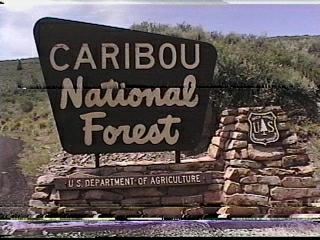
Campground List
CAMPGROUND NAME: Big Springs

VISIT DATE: 07/24/2001

UPDATE DATE:  9/23/2020

STATE: Idaho

REGION: Intermountain

RANGER DISTRICT: Westside North

NEAREST CITY/TOWN: Lava Hot Springs

RESERVATIONS: 1-877-444-6777 or make on-line reservation

DIRECTIONS:
In Lava Hot Springs, ID, at the intersection of US Rt. 30 and
Blaser Hwy./Old US Rt. 30, take Blaser Hwy. north 9 miles to
"Campground Big Springs" sign (Pebble Creek Rd.).  After sign
turn left onto Pebble Creek Rd. (gravel) and go 0.6 miles to a
"T" intersection.  Turn left and go 6.2 miles (wide single-lane)
to a "Y" intersection.  Bear left and go 0.2 miles to campground.

GENERAL COMMENTS:
The elevation is 6,500 ft.

The campground, pack it in, pack it out, is composed of two
sections.  All camp sites have lantern posts and good privacy.
The first section, with longer parking aprons and more sun, is
located on the right before the fee station and directly across
from the Boundary Trail parking area.  This section has two
unnamed loops on a flat, sagebrush and Aspen area.  Some camp
sites are tucked into widely spaced Douglas fir located on the
perimeter.  The second section is a long single spur with Pebble
Creek separating the more open, juniper-shaded sites from those
that meander up a hillside into a dense stand of mixed conifers
and maple.  The Big Springs Nature Trail provides a pleasant
after-dinner stroll.  A day trip to Lava Hot Springs is a
possibility.

SEASONS
Open Seasonal: Yes
Open All Year: No

Seasonal Comment:
Open May 24 through October 30

RATE AND MAXIMUM STAY PERMITTED
Rate: $12 per day - single
$24 per day - double
Maximum Stay Permitted (days): 14

CAMPGROUND SITE CONFIGURATION
No. RV Sites: 0
No. Tent Sites: 0
No. Combined Sites (Tent or RV): 29

   Total Sites: 29

Tent Pads: Yes
Open Sites: Yes
Wooded Sites: Yes

No. Tables on Sites: 29
No. Grilles on Sites: 29
Equestrian Camping:  No

RV INFORMATION
Hookups: None
No. RV Pull Throughs: 0
Waste Station: No
Average Parking Apron Size: 12.5' X 50'

Comments:
The parking aprons are gravel.

FACILITIES
Vaults: Yes
Flush Toilets: No
Hot Showers: No
Wheelchair Friendly Toilets: Yes

Public Phone: No
Playground: No
No. Water Spigots (non-site): 8
  No. Threaded: 7

WATER SPORTS - None

HIKING
Big Springs Nature Trail (foot) - 0.5 miles
Boundary Trail #072 (multi-use) - 7 miles
    provides access to a network of trails

FISHING
Cutthroat and Rainbow trout

CAMPGROUND NAME: Cloverleaf

VISIT DATE: 07/20/2001

UPDATE DATE:  9/23/2020

STATE: Idaho

REGION: Intermountain

RANGER DISTRICT: Montpelier

NEAREST CITY/TOWN: St. Charles

RESERVATIONS: 1-877-444-6777 or make on-line reservation

DIRECTIONS:
In St. Charles, ID, at Minnetonka Cave sign, turn onto an
unidentified paved road and go west 8.1 miles to campground sign.
Turn left at sign into campground.

GENERAL COMMENTS:
The elevation is 7,100 ft.

NOTE: The campground is actually in Cache National Forest, but is
administered by Caribou National Forest.

The campground, located near St. Charles Creek, is comprised of a
large and small loop in a pleasant mixture of Aspen, Lodgepole
pine and fir trees.  While a few campsites are on a small grassy
meadow, most are tucked well back into the trees.  However, the
closeness of the sites provides poor to fair privacy.  The
interior road is narrow and has close-growing trees giving the
campground a closed-in feeling.  The understory is grass with a
heavy middlestory of young Aspen and conifers.

Two good day trips from the campground are the Minnetonka Cave
and North Beach of the Bear Lake State Park.  Minnetonka Cave has
nine rooms and is about 2 miles from the campground.  The
excellent 90-minute guided tour involves 400 steps; bring a
jacket or sweater.  The state park is 4.8 miles from St. Charles
and provides a boat ramp and large sandy beach.  There are no
restrictions on the 160-square mile Bear Lake, but there is a fee
to access the state park.

SEASONS
Open Seasonal: Yes
Open All Year: No

Seasonal Comment:
Open June 2 through September 4
Day.

RATE AND MAXIMUM STAY PERMITTED
Rate: $10 per day - single
$16 per day - double
Maximum Stay Permitted (days): 14

CAMPGROUND SITE CONFIGURATION
No. RV Sites: 0
No. Tent Sites: 0
No. Combined Sites (Tent or RV): 18

   Total Sites: 18

Tent Pads: No
Open Sites: Yes
Wooded Sites: Yes

No. Tables on Sites: 17
No. Grilles on Sites: 16
Equestrian Camping:  No

RV INFORMATION
Hookups: None
No. RV Pull Throughs: 1
Waste Station: No
Average Parking Apron Size: 12' X 35'

Comments:
The parking aprons are paved.  An RV waste station with potable
water is available for no fee in Paris, ID off US Rt. 89.

FACILITIES
Vaults: No
Flush Toilets: Yes
Hot Showers: No
Wheelchair Friendly Toilets: No

Public Phone: No
Playground: No
No. Water Spigots (non-site): 5
  No. Threaded: 0

WATER SPORTS - None

HIKING
Minnetonka Cave Trail (foot) - 1 mile
    access the Minnetonka Cave

FISHING - No

Comments:
Cutthroat and Brook trout are available in the nearby St. Charles
Creek.

CAMPGROUND NAME: Emigration

VISIT DATE: 07/18/2001

UPDATE DATE:  9/23/2020

STATE: Idaho

REGION: Intermountain

RANGER DISTRICT: Montpelier

NEAREST CITY/TOWN: Montpelier

RESERVATIONS: 1-877-444-6777 or make on-line reservation

DIRECTIONS:
From Montpelier, ID, take US Rt. 89 south 4.7 miles to State Rt.
36 (in Ovid, ID).  Continue straight onto Rt. 36 and go 10.9
miles to campground sign.  Turn left at sign and go 0.1 miles to
campground.

GENERAL COMMENTS:
The elevation is 7,100 ft.

NOTE: The campground is actually in Cache National Forest, but
administered by Caribou National Forest.

The campground, comprised of two loops, is in a dense, lush stand
of spruce, other conifers, and Aspen.  It is convenient for an
overnight stay from State Rt. 36 or longer for a great forest
experience and access to the 55-mile multiple-use Highline Trail.
During mid-August Huckleberries are abundant.  Good privacy
between campsites; grass and wildflower understory.

SEASONS
Open Seasonal: Yes
Open All Year: No

Seasonal Comment:
Open June 2 through September 4

RATE AND MAXIMUM STAY PERMITTED
Rate: $17 per day - single
$28 per day - double
Maximum Stay Permitted (days): 14

CAMPGROUND SITE CONFIGURATION
No. RV Sites: 0
No. Tent Sites: 1
No. Combined Sites (Tent or RV): 23

   Total Sites: 24

Tent Pads: No
Open Sites: Yes
Wooded Sites: Yes

No. Tables on Sites: 24
No. Grilles on Sites: 24
Equestrian Camping:  No

RV INFORMATION
Hookups: None
No. RV Pull Throughs: 1
Waste Station: No
Average Parking Apron Size: 12' X 46'

Comments:
The parking aprons are paved.  An RV waste station is located at
Montpelier Visitor Center at the intersection of US Rts. 30 and
89 - no fee.

FACILITIES
Vaults: No
Flush Toilets: Yes
Hot Showers: No
Wheelchair Friendly Toilets: No

Public Phone: No
Playground: No
No. Water Spigots (non-site): 6
  No. Threaded: 0

Comments:
Kitchen water can be disposed in a deep sink located at each
toilet.

WATER SPORTS - None

HIKING
Highline Trail #316 (multi-use) - 55 miles

FISHING - No

CAMPGROUND NAME: Mill Canyon

VISIT DATE: 07/19/2001

UPDATE DATE:  9/23/2020

STATE: Idaho

REGION: Intermountain

RANGER DISTRICT: Soda Springs

NEAREST CITY/TOWN: Soda Springs

RESERVATIONS: No

DIRECTIONS:
From Soda Springs, ID, take State Rt. 34 north 10.2 miles to
Black River Park sign.  Turn right at sign and go 10.4 miles to
an intersection.  Continue straight over railroad tracks and go
3.2 miles to campground sign.  Turn left at sign and go 0.2 miles
to campground.

NOTE: Last 2.7 miles are gravel surface.

GENERAL COMMENTS:
The elevation is 6,700 ft.

This little campground stretches up Mill Canyon between a
babbling brook called Mill Creek and a dense stand of Lodgepole
pines.  This is a quiet campground far from crowds with lots of
solitude and privacy.  The Blackfoot River is across from
campground entrance.  The understory and middlestory is comprised
of grass, wild roses and other wildflowers, and River willow
shrubs.

SEASONS
Open Seasonal: Yes
Open All Year: Yes

Seasonal Comment:
Services provided weekend afer Memorial Day through October 15

RATE AND MAXIMUM STAY PERMITTED
Rate: $8 per day
Maximum Stay Permitted (days): 14

CAMPGROUND SITE CONFIGURATION
No. RV Sites: 0
No. Tent Sites: 1
No. Combined Sites (Tent or RV): 9

   Total Sites: 10

Tent Pads: No
Open Sites: Yes
Wooded Sites: Yes

No. Tables on Sites: 10
No. Grilles on Sites: 9
Equestrian Camping:  No

RV INFORMATION
Hookups: None
No. RV Pull Throughs: 3
Waste Station: No
Average Parking Apron Size: 16' X 40'

Comments:
The parking aprons are gravel and grass.  An RV waste with
potable water is located in Soda Springs, ID.  On US Rt. 30 at
intersection of 2nd South and 2nd East, take 2nd East north to
waste station on right - no fee.

FACILITIES
Vaults: Yes
Flush Toilets: No
Hot Showers: No
Wheelchair Friendly Toilets: No

Public Phone: No
Playground: No
No. Water Spigots (non-site): 0
  No. Threaded: 0

WATER SPORTS - None

HIKING - No

FISHING
In Blackfoot River - Cutthroat and Rainbow trout

CAMPGROUND NAME: Montpelier Canyon

VISIT DATE: 07/18/2001

UPDATE DATE:  9/23/2020

STATE: Idaho

REGION: Intermountain

RANGER DISTRICT: Montpelier

NEAREST CITY/TOWN: Montpelier

RESERVATIONS: 1-877-444-6777 or make on-line reservation

DIRECTIONS:
From Montpelier, ID, take US Rt. 89 north 2.8 miles to campground
sign.  Turn right at sign into campground.

GENERAL COMMENTS:
The elevation is 6,400 ft.

The campground has two unnamed loops stretching along Montpelier
Creek among a dense growth of River willows, which  provide
excellent privacy between camp sites.  The loop to the right of
the entrance is smaller with shorter parking aprons and a tight
radius on the loop's curve.  The loop on the left of the entrance
has longer parking aprons but some sites limit area for tents to
parking apron.  The lack of shade and location in a steep sided
canyon can produce very warm days and mosquitoes.

SEASONS
Open Seasonal: Yes
Open All Year: No

Seasonal Comment:
Open May 19 through September 11

RATE AND MAXIMUM STAY PERMITTED
Rate: $10 per day
Maximum Stay Permitted (days): 14

CAMPGROUND SITE CONFIGURATION
No. RV Sites: 0
No. Tent Sites: 0
No. Combined Sites (Tent or RV): 14

   Total Sites: 14

Tent Pads: No
Open Sites: Yes
Wooded Sites: No

No. Tables on Sites: 11
No. Grilles on Sites: 7
Equestrian Camping:  No

RV INFORMATION
Hookups: None
No. RV Pull Throughs: 0
Waste Station: No
Average Parking Apron Size: 12' X 37'

Comments:
The parking aprons are gravel and grass.  An RV waste station is
located at Montpelier Visitor Center at the intersection of US
Rts. 30 and 89 - no fee.

FACILITIES
Vaults: Yes
Flush Toilets: No
Hot Showers: No
Wheelchair Friendly Toilets: No

Public Phone: No
Playground: No
No. Water Spigots (non-site): 0
  No. Threaded: 0

WATER SPORTS - None

HIKING - No

FISHING
Rainbow, Brook, and Brown trout

CAMPGROUND NAME: Porcupine

VISIT DATE: 07/20/2001

UPDATE DATE:  9/23/2020

STATE: Idaho

REGION: Intermountain

RANGER DISTRICT: Montpelier

NEAREST CITY/TOWN: St. Charles

RESERVATIONS: 1-877-444-6777 or make on-line reservation

DIRECTIONS:
In St. Charles, ID, at Minnetonka Cave sign, turn onto an
unidentified paved road and go west 7.5 miles to campground sign.
Turn left at sign into campground.

GENERAL COMMENTS:
The elevation is 6,900 ft.

NOTE: The campground is actually in Cache National Forest, but is
administered by Caribou National Forest.

The campground, composed of two unnamed loops, stretches along
St. Charles Creek in an area lightly wooded with Aspen and
conifers.  The loop on the right of the campground entrance has
only vaults and is a bit more shaded.  The left hand loop has the
flush toilet.  Some camp sites are adjacent to the creek.
Although there is a lush understory of grass and wild roses, most
sites enjoy only poor to fair privacy.

Two good day trips from the campground are Minnetonka Cave and
North Beach of the Bear Lake State Park.  Minnetonka Cave has
nine rooms and is about 2 miles from the campground.  The 90-
minute guided tour involves 400 steps; bring a jacket or sweater.
The state park is 4.8 miles from St. Charles and provides a boat
ramp and large sandy beach.  There are no restrictions on the
160-square mile Bear Lake, but there is a fee to access the state
park.

SEASONS
Open Seasonal: Yes
Open All Year: No

Seasonal Comment:
Open May 24 through September 9.  No potable water after Labor
Day.

RATE AND MAXIMUM STAY PERMITTED
Rate: $10 per day - single
$16 per day - double
Maximum Stay Permitted (days): 14

CAMPGROUND SITE CONFIGURATION
No. RV Sites: 0
No. Tent Sites: 0
No. Combined Sites (Tent or RV): 15

   Total Sites: 15

Tent Pads: No
Open Sites: Yes
Wooded Sites: Yes

No. Tables on Sites: 15
No. Grilles on Sites: 15
Equestrian Camping:  No

RV INFORMATION
Hookups: None
No. RV Pull Throughs: 2
Waste Station: No
Average Parking Apron Size: 13' X 40'

Comments:
The parking aprons are paved.  There is an RV waste station with
potable water in Paris, ID.  It is 6 miles north of campground
off US Rt. 89; follow signs in Paris - no fee.

FACILITIES
Vaults: Yes
Flush Toilets: Yes
Hot Showers: No
Wheelchair Friendly Toilets: Yes

Public Phone: No
Playground: No
No. Water Spigots (non-site): 3
  No. Threaded: 0

Comments:
Only the vaults are wheelchair friendly.

WATER SPORTS - None

Comments:
See General Comments about the 160-acre Bear Lake.

HIKING - No

FISHING
Cutthroat and Brook trout

CAMPGROUND NAME: Scout Mountain

VISIT DATE: 07/25/2001

UPDATE DATE:  9/23/2020

STATE: Idaho

REGION: Intermountain

RANGER DISTRICT: Westside North

NEAREST CITY/TOWN: Pocatello

RESERVATIONS: 1-877-444-6777 or make on-line reservation

DIRECTIONS:
From Pocatello, ID, take I-15 south 3.7 miles to Mink Creek
Recreation Area sign (Exit 63).  At end of exit ramp, turn right,
following Mink Creek Recreation Area sign, and go 0.1 miles to
next sign (Ft. Hall Mine).  Turn left onto Ft. Hall Mine and go
0.2 miles to still another sign.  Turn right onto Portneuf and go
0.3 miles to a "Y" intersection and "Mink Creek X-C" sign.  Bear
left, then turn left onto Mink Creek and go 4.6 miles to Scout
Mountain Recreation Area sign.  Turn left at sign and go 5.3
miles to campground sign.  Turn left at sign into campground.

GENERAL COMMENTS:
The elevation is 6,900 ft.

The campground, pack it in, pack it out, has three overlapping
loops (A, B, and C) in a pleasant stand of Douglas fir.  Most
camp sites are surrounded by a thick middlestory of Aspen, wild
roses and deciduous trees.  Loop A is the largest loop and
follows the campground's perimeter.  Loop B is the smallest and
least maintained.  Loop C has camp sites with paved parking
aprons and the least middlestory.  The campground is convenient
to the Pocatello Archery Range.

SEASONS
Open Seasonal: Yes
Open All Year: No

Seasonal Comment:
Open May 22 through September 24

RATE AND MAXIMUM STAY PERMITTED
Rate: $12 per day - single
$24 per day - double
Maximum Stay Permitted (days): 14

CAMPGROUND SITE CONFIGURATION
No. RV Sites: 0
No. Tent Sites: 0
No. Combined Sites (Tent or RV): 25

   Total Sites: 25

Tent Pads: No
Open Sites: Yes
Wooded Sites: Yes

No. Tables on Sites: 22
No. Grilles on Sites: 22
Equestrian Camping:  No

RV INFORMATION
Hookups: None
No. RV Pull Throughs: 3
Waste Station: No
Average Parking Apron Size: 13' X 50'

Comments:
Some parking aprons are paved, others are gravel.  A waste
station is available in Pocatello, ID with potable water and no
fee.  From I-15, take Exit  67 (US 30 & 91) - follow dump symbol
signs.

FACILITIES
Vaults: Yes
Flush Toilets: No
Hot Showers: No
Wheelchair Friendly Toilets: Yes

Public Phone: No
Playground: No
No. Water Spigots (non-site): 12
  No. Threaded: 3

WATER SPORTS - None

HIKING
Scout Mountain Nature Trail (foot - loop) - 1 mile
East Mink Trail #64 (multi-use) - 4 miles

FISHING - No

CAMPGROUND NAME: Summit

VISIT DATE: 07/23/2001

UPDATE DATE:  9/23/2020

STATE: Idaho

REGION: Intermountain

RANGER DISTRICT: Westside North

NEAREST CITY/TOWN: Malad City

RESERVATIONS: No

DIRECTIONS:
From Malad, ID, take I-15 north 8.5 miles to Devil Creek Reservoir
(Exit 22).  At end of ramp, turn right onto roadway that
parallels I-15 and go 3 miles to "Campground Summit" sign (11000
North).  Turn left at sign onto 11000 North (gravel) and go 1.2
miles to 100 West.  Turn right onto 100 West (single-lane, gravel
and dirt) and go 1.8 miles to campground.

GENERAL COMMENTS:
The elevation is 6,400 ft.

The campground, pack it in, pack it out, stretches along Mill
Creek in a stand of Douglas fir and mostly maple trees.  A few
camp sites have "V" shaped parking aprons.  The creek can be
heard throughout the campground.  The moisture from the creek
produces a lush understory, dominated by wild roses and other
shrubs all of which provide good privacy between camp sites.

SEASONS
Open Seasonal: Yes
Open All Year: No

Seasonal Comment:
Open May 24 through October 30.

RATE AND MAXIMUM STAY PERMITTED
Rate: $14 per day
Maximum Stay Permitted (days): 14

CAMPGROUND SITE CONFIGURATION
No. RV Sites: 0
No. Tent Sites: 0
No. Combined Sites (Tent or RV): 10

   Total Sites: 10

Tent Pads: Yes
Open Sites: No
Wooded Sites: Yes

No. Tables on Sites: 10
No. Grilles on Sites: 10
Equestrian Camping:  No

RV INFORMATION
Hookups: None
No. RV Pull Throughs: 1
Waste Station: No
Average Parking Apron Size: 12' X 32'

Comments:
The parking aprons are gravel.  The interior road is a narrow,
single-lane dirt road.

FACILITIES
Vaults: Yes
Flush Toilets: No
Hot Showers: No
Wheelchair Friendly Toilets: Yes

Public Phone: No
Playground: No
No. Water Spigots (non-site): 4
  No. Threaded: 4

WATER SPORTS - None

HIKING
Summit Trail #1230 (Multi-use) - 12 miles

Convenient to the following multi-use trails:
Wright Lake National Recreation Trail - 6.5 miles
Indian Mill Trail - 5 miles
South Canyon #1232 (loop) - 8 miles
Kents Canyon - 8 miles

FISHING
Cutthroat and Rainbow trout

CAMPGROUND NAME: Summit View

VISIT DATE: 07/20/2001

UPDATE DATE:  9/23/2020

STATE: Idaho

REGION: Intermountain

RANGER DISTRICT: Montpelier

NEAREST CITY/TOWN: Montpelier

RESERVATIONS: 1-877-444-6777 or make on-line reservation

DIRECTIONS:
From Montpelier, ID, take State Rt. 30 west 10.7 miles to
Georgetown, ID.  In Georgetown, at Georgetown Canyon sign, turn
east at sign and go 2.3 miles to campground sign (Forest Rt.
095).  Turn left at sign onto Rt. 095 and go 5.5 miles to another
campground sign.  Turn right at sign into campground.

GENERAL COMMENTS:
The elevation is 7,200 ft.

The campground is comprised of two sections in a stand of
Lodgepole pine and other conifers.  While the understory is only
grass, the widely spaced camp sites and dense growth of trees
provide good privacy.  The section on the left side of the
campground entrance includes group sites (not included in site
count) and has a small turn-around for RVs; to avoid problems,
recommend taking left turn before group area.

SEASONS
Open Seasonal: Yes
Open All Year: No

Seasonal Comment:
Open June 1 through September 2

RATE AND MAXIMUM STAY PERMITTED
Rate: $14 per day - May 24 through September 3
$6 per day - September 4 through October 2
Maximum Stay Permitted (days): 14

CAMPGROUND SITE CONFIGURATION
No. RV Sites: 0
No. Tent Sites: 0
No. Combined Sites (Tent or RV): 17

   Total Sites: 17

Tent Pads: No
Open Sites: No
Wooded Sites: Yes

No. Tables on Sites: 17
No. Grilles on Sites: 17
Equestrian camping: No

RV INFORMATION
Hookups: None
No. RV Pull Throughs: 1
Waste Station: No
Average Parking Apron Size: 13' X 45'

Comments:
The parking aprons are grass and dirt.  An RV waste station is
located at Montpelier Visitor Center at the intersection of US
Rts. 30 and 89 - no fee.

FACILITIES
Vaults: Yes
Flush Toilets: No
Hot Showers: No
Wheelchair Friendly Toilets: No

Public Phone: No
Playground: No
No. Water Spigots (non-site): 4
  No. Threaded: 4

WATER SPORTS - None

HIKING - No

FISHING - No

CAMPGROUND NAME: Willow Flat

VISIT DATE: 07/18/2001

UPDATE DATE:  9/23/2020

STATE: Idaho

REGION: Intermountain

RANGER DISTRICT: Montpelier

NEAREST CITY/TOWN: Preston

RESERVATIONS: 1-877-444-6777 or make on-line reservation

DIRECTIONS:
From Preston, ID, take US Rt. 91 south 2.7 miles to Cub River-
Deer Cliff sign (Cub River Rd.).  Turn left at sign onto Cub
River Rd. and go 12 miles to a Willow Flat sign at an
intersection.  Turn right at intersection and go 2.2 miles to
campground.

NOTE: Last 5.5 miles are on a gravel surface.

GENERAL COMMENTS:
The elevation is 6,300 ft.

NOTE: The campground is actually in Cache National Forest, but
administered by Caribou National Forest.

The campground has two unnamed sections located along Cub River.
Most camp sites are tucked into a forest of mixed pine,
cottonwood, willow, maple, Aspen, and juniper - quite a variety
of trees!  Most camp sites are adjacent to the clear-running Cub
River which is about one stride wide in places.  Wild roses,
other wildflowers, and butterflies decorate the campground.  Elk,
deer and moose visit occasionally to check on campers.  The
tables for some camp sites are across the "river" from the
parking apron.  This is a nice campground for the whole family.
There are lamp poles at some sites.  Site #1 is accessed via a
low-water bridge.

SEASONS
Open Seasonal: Yes
Open All Year: No

Seasonal Comment:
Open May 24 through September 2

RATE AND MAXIMUM STAY PERMITTED
Rate: $17 per day - single
$28 per day - double
$6 per day - September 4 through October 3
Maximum Stay Permitted (days): 14

CAMPGROUND SITE CONFIGURATION
No. RV Sites: 0
No. Tent Sites: 4
No. Combined Sites (Tent or RV): 47

   Total Sites: 51

Tent Pads: No
Open Sites: Yes
Wooded Sites: Yes

No. Tables on Sites: 51
No. Grilles on Sites: 51
Equestrian camping: No

RV INFORMATION
Hookups: None
No. RV Pull Throughs: 6
Waste Station: No
Average Parking Apron Size: 14' X 50'

Comments:
The parking aprons are gravel.

FACILITIES
Vaults: Yes
Flush Toilets: Yes
Hot Showers: No
Wheelchair Friendly Toilets: Yes

Public Phone: No
Playground: No
No. Water Spigots (non-site): 14
  No. Threaded: 14

Comments:
Wheelchair friendly toilet is in section on north side of river.

WATER SPORTS - None

HIKING
Sam Parkinson Spring (foot) - 0.5 miles
Cub River Springs-Willow Flat (foot) - 3 miles
      connects with the Highline Trail

FISHING
Rainbow, Brook and Cutthroat trout
|