Our 1994 trip to Canada – Prince Edward Island and Nova Scotia
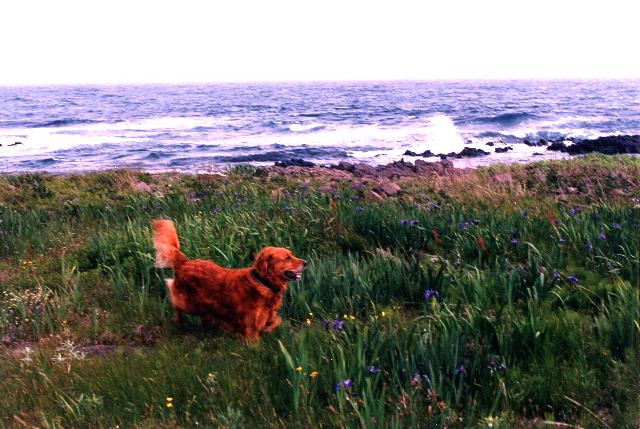
This “report” was written by Fred right after our 1994 trip to Canada. I think you will see Fred, our Golden Retriever, Tory, enjoyed the whole experience. It can safely be said, our ten days camping in Canada was where our current lifestyle began.
From the beginning, it was our intent to concentrate on eastern Canada’s countryside and seacoasts and avoid large cities. We camped in a large tent except for a few of nights when a motel was more convenient. Note: This is a very long article.
June 18
We departed Burke, VA for Westborough, MA on the first leg of our trip. Here we stayed at a Ramada Inn and visited Fred’s mother for the evening. Toting along a dog when traveling requires some preplanning for many ‘innkeepers’ do not allow animals.
June 19
The drive north along the New Hampshire and Maine Turnpikes (I-95) northward is pretty and relaxing. Freeport, Maine is an important stop for those who would enjoy shopping at L.L. Bean and the many factory outlet shops. If any time is going to be spent in Freeport, suggest getting off the Turnpike just before there and driving north on Rt. 1. The number of outlet shops will boggle the mind.
If hungry, look for a restaurant on the right side, sitting on a hill that is painted in blue and white. It will appear about the time the Freeport exit signs are displayed. If you see it too late, no problem. Get off at the next exit and go south on Rt. 1. Don’t remember the restaurant’s name but it has good American food and a wonderful view from the porch.
Once in Nova Scotia, we started exchanging American for Canadian dollars. At the time we were there, the exchange rate was 37 percent (137%) on the American dollar. Go to credit unions and banks for the best rates. But, banks will charge a fee (about $2.00) to cash travelers checks. Be careful in restaurants or other places as the exchange there can be as low as 20 percent. I have to say I was not pleased with making money off the Canadians. On the other hand, taxes there on just about everything were 17 percent. There is a national tax (GST) and a provincial tax (PST). We understood much of the tax was to pay for their national health care system. Is this what we’re headed for in the States? Keep your receipts because some will qualify for refund check with Canadian Custom folks.
June 20
Our goal on this day was to drive from St. John to the Prince Edward Island National Park on PEI. Here we would stay until June 23.
The drive to the Park is a leisurely five hours. To get to PEI (across the Northumberland Strait), we took a car ferry from Cape Tormentine, NB to Borden, PEI. The ferry ride took forty-five minutes. It is free and runs every hour on the half hour. Although we took several ferries on the trip, waiting time for all of them was no more then fifteen to twenty minutes. Waiting time can be considerable during high-season. Our trip was timed to take advantage of kids still being in school, both in the US and Nova Scotia. We also hoped to be ahead of the insects.
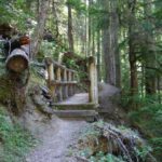
PEI is where we began camping out. We stayed at the Cavendish Campground in the National Park. It was right on the ocean and simply beautiful. The facilities were great – restrooms and hot showers were plentiful and clean. If camping is your thing, we recommend Canada’s National Parks. From our own experiences and discussions with others, the sites are consistently excellent in PEI and NS. The downside is reservations are not taken and there can be a wait to get in.
 After we got to the Park, we set up camp, picked up literature and walked the beach. Beaches (and soil) are a reddish-brown color. The Island has no rock bed, so all the ‘rock’ formations are sandstone, some are spectacular. Because of the lack of a rock bed, some roads can be rough.
June 21
We drove from Cavendish Rt. 11. This route took us along the southern coast through Bedeque and Egmont Bay areas past many fishing villages and Lupine flowers blooming in many colors along the roadsides.
In a tiny town called Cap-Egmont, we visited the Bottle Houses (Les Maisons de Bouteilles). In the 1970s, a retired fisherman cemented over 25,000 bottles of all shapes, sizes and colors into a chapel with altar, a tavern and a six-gabled house. This was a sight to behold, especially from the inside in full sunlight. From Cap-Egmont we continued on to the inland town of O’Leary.
 Why O’Leary? Well, one major agricultural industry on the Island is potatoes. In O’Leary there is a potato museum. We found the idea intriguing, so off we went. The presentation is excellent. On the grounds are three additional buildings – an old school house, church and a community center. Inside the community center was a collection of old farming equipment. All of this was interesting and a nice diversion.
By the way, before I forget, here are some observations to pass along about the Island and our trip. First, PEI is like a golf course. The grass is unbelievably green and immaculately groomed, growing right up to the pavement or dirt roadways. One criticism we heard about PEI via the Internet was that it is over groomed. We looked upon this characteristic as one of the Island’s unique features. Another special feature of PEI was this guy on the radio who announced the obituaries. His voice was somber and especially suited to this task. Throughout our trip, even if there was no store, cafe, or gasoline and no matter how small the town or village was, there was a cemetery, a church and a community center. Last, the hungry mosquitos were everywhere! Whether camping or not, bring insect repellent (industrial strength).

From O’Leary, we drove Rt. 14, one of two coastal routes on the Island. (This section, extending along the western coast and about fifty or so miles inland, is known as “Lady Slipper.” (Look at the map and you’ll see why.) The drive was beautiful. One special sight was “Elephant Rock.” Elephant Rock is just north of Norway on Rt. 14 and is accessed by a dirt road. Take that road, get out of the car, walk around, take pictures and enjoy. Expect wind and a bit of a chill.
At North Cape, we observed a windmill project and lots of water. Back to Cavendish. To us, one exciting thing we did was getting off on to dirt roads that seemed to lead nowhere. Sometimes we ended up on private property (damned tourists), but more times then not, there was a small fishing village or some other interesting site, e.g., Elephant Rock. More about other discoveries later.
During the day, the clouds began to gather. As we got closer to our campsite, they got downright threatening. That night it poured and the winds howled. Our tent got buffeted by the winds. Inside, we felt as though someone was hitting it with a baseball bat. But, it held and we stayed dry. (Our tent is one of those igloo types, six feet high and sleeps three.) Others campers though did some bailing during the night. The next morning we were told gusts hit 60km. Do I love camping? Yeah, sure. (Note from Suzi: this trip was my graduation gift from Fred. I love camping; he is not that enthusiastic. What a trouper! 🙂
June 22
The next day we headed for Ft. Amherst, just southeast of Charlottetown. This site marks the first French settlement on the Island and the British fort that ousted the French. All that remains of the 200 year-old fort are earthworks. The location overlooks the Hillsborough Bay and is very scenic. This is an ideal place to bring a picnic lunch, absorb the views and let the kids romp. Find a trail. Fly a kite. Whatever, but don’t forget the insect repellent.
Next, we headed southwest to Rice Point and then DeSable. As expected, the views along the Northumberland Strait were terrific. No disappointments here.
We are social hikers and wanted to get in at least one hike while on PEI. We read about a circuit hike near our campsite and decided to spend the rest of the day on that trail. Named Homestead, it is 5.5 miles long, meanders through woods, along a bay, farmland and the Black River. It is flat and suitable for both walking and biking. We enjoyed the hike and recommend it.
June 23
Our next stop was Cape Breton Island, Nova Scotia (NS) where we’d spend four days. We packed up the tent and drove to Wood Islands, PEI and caught the ferry to Caribou, NS. In the morning, the ferry left at 9:15 and 10:44 and there was a fee. The ferry ride took a little more then an hour.
We had planned to stay at a private campground in Cheticamp on Cape Breton Island. It took four hours to reach Cheticamp after the ferry docked. At the campground, we took a drive inside and promptly departed. It was a trailer park and did not suit our tastes. We drove into the Cape Breton Highlands National Park and found a great campground. Again, the Canadian government outdid itself . We found a site nestled in some trees and close to the facilities. BTW, this campground, is not shown on the map provided by the NS tourist bureau. It is at the entrance to the Park.
 June 24
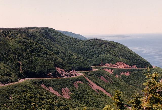
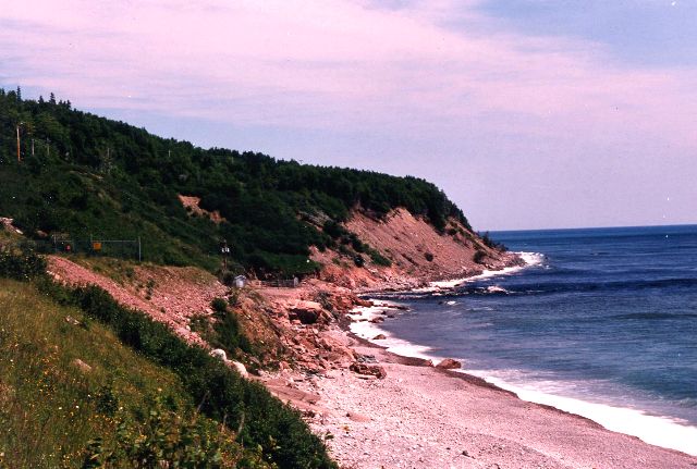
The next morning, we drove part of the famous Cabot Trail. This drive took us from the campground on Cape Breton Island to Neils Harbor on the northeast side of the Island. One way to describe the Cabot Trail is think Big Sur, California. The west side is much like the northern portion of the Big Sur while the east side is similar to the southern end. Whatever, it is a continuous spectacle of natural beauty. Unlike PEI with its sandstone base, Cape Breton sits on bedrock and the mountains, although small, are volcanic rock. The Trail winds up and down and around the mountains in a zigzag, curvy fashion usually overlooking the ocean and tiny fishing villages. There were many breathtaking views. It was all mesmerizing. One can easily go crazy with the camera. Again, we wandered off the main road. I’ll describe two such memorable jaunts.
 The first was to a place called “Meat Cove.” It is at the very northern tip of Cape Breton Island. The drive, on a dirt road, was harrowing with steep, hairpin curves, no guard rails and the drops breathtaking. Toward the end of the road, a few homes could be seen in a valley and off to the right was the Atlantic. We suddenly came to the end of the road and was siting on a bluff overlooking the ocean. We parked on a grassy knoll, which we learned later was a private campground. After a few minutes of looking in awe at the view and the shear drop to the ocean, a man walked up and asked if he could be of assistance.
His name is Kenneth McLellan and is of Scottish-Irish descent. His family has owned Meat Cove for seven generations and their primary occupation was fishing. Because of the recent moratorium on Cod fishing by the Canadian government, Kenneth has had to find way to supplement his income. Of the many acres owned by the family, Kenneth has eight of them. He is developing a part of those acres into the campground where were were parked. Although primitive, people now go there to camp – tenting and “‘trailoring.” He expects to have hot showers installed in about a year. (Note from Suzi: I understand people using Kenneth’s campground can arrange for dinner with a family in the Cove.)
Kenneth also charters out his fishing boat for deep sea fishing and whale-watching. During hunting season, he guides hunters into the back country. He loves the outdoors and looks the part. One way to describe Kenneth is the Marlboro Man without the horse and cigarette. We wish we could have spent more time with Kenneth, but we had to move on. When we go back to Nova Scotia, it’s a good bet we’ll return to Meat Cove and visit with Kenneth.
 Our second memorable jaunt that day was to a little fishing village called White Point. It is easily accessed and located on the northeast corner of the Island. There is a paved side road off Cabot Trail which dead ends in the village. As we descended a steep hill into the village, we saw the classic view of a fishing village nestled in Aspy Bay. Great for pictures. But, once into the village, a dirt road off to the side that disappeared over the top of a hill caught Suzi’s eye.
 We looked at each other and without a word, drove up this dirt road. At the top, we found the real White Point before us. It stretched out for about three quarters of a mile to a point into Aspy Bay. This jut of land was covered with high, fluffy like green grass with gray rocks protruding up throughout the area. There were no buildings, trees or shrubs. We could have walked, but decided to put our vehicle in four-wheel drive and cautiously crept around this piece of land. We stopped, walked around for a while, let the dog run and took pictures. Way out on the point was a white cross. In front of it were white stakes making up a rectangle about fifty feet long and thirty feet wide. It was a monument to “‘The Unknown Sailor.” There was no grave site within the marked off area – just grass and rocks.
After leaving White Point, we drove to Neil’s Harbor, took in the sights and than returned to the Cheticamp Campground. Somewhere along the way, we decided to leave Cheticamp the next day and spend the next two days on the east side of the Island, but still in the Park.
June 25
The next morning we broke camp and retraced our route of the previous day over the Cabot Trail, passed Neil’s Harbor to Ingonish. Here there are two Park campgrounds. One is called Ingonish and the larger campground, Broadcove. Broadcove is where we pitched camp and it is highly recommended. We didn’t do much except relax. It’s good to do nothing occasionally.
June 26
The next morning we drove to Louisburg, southeast of Sydney. We visited the Louisburg National Historic Site. Based on over 700 pages of plans and architectural drawings found in France, the Canadian government restored (from the ground up) the 18th-century Fortress of Louisburg. It is a replica of this colonial seaport, but only one-quarter of it has been restored. The theme of the Fortress is to represent a day in the summer of 1744. Townspeople, soldiers and workers (dressed in the appropriate clothes) bustle about like it really is 1744. The realism is incredible and with little effort, easy for one to become a part of that time in history. As the tour books recommend, plan on spending the day there or at least four hours. Don’t worry about getting hungry, because there are period Inns and taverns in which hearty meals are served. One should not leave Nova Scotia without visiting this replica of a historic harbor town. (Note from Suzi: Be sure to purchase a loaf of Soldiers Bread; it is delicious.)
 June 27
We broke camp and drove six hours south to Digby, NS. We had reservations at a private campground, Fundy Spray Trailer Park. Although private with lots of “permanent” trailers, it was clean and friendly. Our objectives for the Digby area were fourfold – drive down Digby Neck; view the Tidal Bore; visit Kejimkujik National Park; and, drive to the east coast, down to the southern tip of NS and north up the west coast back to Digby. We planned on doing this in four days and start the return home on July 1.
 June 28
Driving from Digby Neck to Brier Island requires two car ferries. The ferries are small and although we experienced no appreciable waiting periods, high-season may require some waiting. Similar to Meat Cove, Brier Island is a good place to view the whales from land. Unfortunately, we saw no whales at either location. The drive down Digby Neck was fun and picturesque. (Note from Suzi: The locals throughout our trip were friendly and more then happy to share their time, knowledge and experience. Before leaving Brier Island, visit Mrs. Garrow’s home. She had the best quilting we had seen on the entire trip for reasonable prices. She is 91 – an amazing woman.)
June 29
Today, visited Kejimkujik National Park and drove the circuit mentioned above. It is a beautiful wilderness area in which one can participate in interpretive programs, canoe, hike and camp in remote sections. Unfortunately, weather was turning bad on us – rain, fog, drizzle – the works. We hoped the inclement weather was locally limited. Wrong!
Although we hoped with every mile that the skies would clear, the Gods were not smiling on us. For a good deal of the drive, we were shrouded in light to heavy fog. While on the drive, the weather forecast on the radio was calling for rain, showers, and fog for the next two days. We decided to pack it in and head home a day early. True, with some research we probably could have done some inside stuff but burn out was setting in.
June 30
To return to the U.S., we had to start out by taking a car ferry from Digby to St. John, NB. We had made reservations (highly recommended) for July 1 and successfully changed them to June 30. The ferry cost for us was $86.00. The trip takes two and a half to three hours; the ship was very comfortable.
If there was a downside to this trip, it was having to take the ferry at 5:00 A.M. There were other times, but not until much later in the day. Since we wanted to make Portsmouth, NH on our first leg home, leaving any later was not practical. We had to be at the ferry by 4:00 A.M. That meant getting up at 2:30 A.M. to break camp. (The drive from the campsite to the ferry took about twenty minutes.) The weatherman was right. It was pouring out, really pouring. Taking a campsite down in a down pour is one event everyone should experience but only once. Sitting in our vehicle for an hour waiting for the ferry in thoroughly soaked blue jeans was not exhilarating.
Otherwise, except for the 4th of July holiday traffic, our trip home was uneventful.
IF WE HAD IT TO DO OVER AGAIN . . .
Notwithstanding the inclement weather in Digby, it was anticlimactic. To us, Cape Breton was the highlight of the trip. We would do Digby first, PEI and then Cape Breton. On the way back, we’d consider camping at the Fundy National Park, NB. Did we take on too much? Yeah, probably. We missed out on a lot and didn’t get to do as much hiking as planned. To do this trip, three weeks is better.
With only two weeks, take the ferry from Portland or Bar Harbor, Maine to Yarmouth, NS. But, leave the dog at home. This is too long a ferry ride for an animal. Take three or four days driving north up the east coast of NS to Cape Breton. Camp in the Cape Breton Highlands National Park on the east side and stay there. Drive the Cabot Trail and tour down to Sydney and Louisburg from there. If touring is not in the cards, but just relaxing and hiking are preferences, then stay on the west side at Cheticamp. Return to the U.S. via New Brunswick.
A WORD ABOUT RESTAURANTS
Breakfasts and lunches were fine, but based on our route and when we were ready to eat, dinners were average or below. Actually, there just weren’t that many restaurants. Don’t expect much. But, I have to be honest. I do not like seafood. So, perhaps the problem was me and my ‘meat and potato’ expectations. One restaurant was the exception. It is called Coastal Waters Restaurant and is located just south of Ingonish on the Cabot Trail.
One last thing about restaurants. Two expressions used by the waiters and waitresses in Nova Scotia were really neat – ‘Is your tea good yet?’ and ‘More hot?’ The latter, of course, meant freshening our tea or coffee. One name of a restaurant got my attention – “Lick-A-Chick.”