

August 17, 1959 – earthquake!
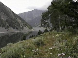 There are dangers in the forests. We recognize this. These dangers seem more like urban legend than reality. However, an earthquake caused scar on a mountain-side visible from US Route 287, in the Gallatin National Forest (MT) and just northwest of Yellowstone National Park, shows us, even in a place of such beauty, a terrible tragedy can occur.
On August 17, 1959, just before midnight, the world tilted and the mountainside was torn away. Sliding rock buried 19 campers (a total of 28 people lost their lives) as 80 million tons of rock and trees tumbled into Madison River Canyon, leaving rubble more than 200 feet deep, and forming the 5-mile long Earthquake Lake. The earthquake that caused the slide was the largest ever recorded in the Rocky Mountains.
Five more campers drowned when displaced air whooshed down the canyon and swept them into the Madison River. Survivors reported the wind generated by the slide was so strong it ripped off their clothes.
A 15-year-old boy, camping with his family, was shaken awake in his tent. Woozy with vertigo, he told his two younger brothers to stay put and then went outside. The first thing he saw was a tree fallen on the family’s car. Then, he looked to his left and saw a huge boulder on top of his father’s tent. Both parents were dead, victims of a second, smaller slide.
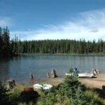
Today, only a few hundred pines have grown back within the slide area. There are small splashes of green within the massive jagged, gray-brown scar of rock that straddles the canyon. It will take decades more, possibly centuries, before evidence of the earthquake fades from the landscape. But the scene of the 1959 tragedy already has evolved from natural disaster to geological attraction.
Along Route 287 on the lake’s north shore, the Gallatin National Forest has highlighted points of earthquake with a self-guided “Madison River Canyon Earthquake Area Auto Tour.” Signposted stops include abandoned sections of the highway ending in boat ramps and a “ghost village” of cabins uprooted by the flood. Atop the rock pile that entombs those 19 campers is the Forest Service’s Earthquake Lake Visitor Center which offers floor-to-ceiling views of the rubble. The magnitude of the rockslide catches most people’s attention, but it’s the stories of those who survived that offer the most drama.
The epicenter the earthquake was 17 miles west of the rockslide, near the resort community of Hebgen Lake. When the earth’s crust shifted that night, the man-made lake tilted down at one end, setting off a giant wave that rolled across the lake and back. Cabins and other buildings were destroyed. No one was killed by the wave, but it triggered a flurry of speculation that the dam at the lake’s west end would give way and flood downstream communities. The town of Ennis (yes, that’s where my daughter and her family live) was quickly evacuated, but the dam held.
Bears, mosquitoes, even falling trees are dangers a camper is most likely to encounter but the Yellowstone National Park area is still active with numerous earthquakes occurring each year. To date, none have been as destructive of the one on August 17, 1959 but to aware of the possibilities.

I was there on August 17, 1959. I was a kid, there with my parents and sister and brothers. We were staying in a cabin in Yellowstone. Middle of the night, we woke to the cabin shaking and mom and dad hustled us out to spend the night in the car, not knowing how strong the cabin was.
The timing of all the geysers were off, including Old Faithful. Some roads were closed. Rangers were off doing rescue and recovery work so Ranger talks were cancelled.
I’ll never forget it.